Jędrzychowice geodata
Jędrzychowice (Lower Silesia) is a populated place; located in Poland in Europe/Warsaw (GMT+2) time zone. With population of 643 people, there are 3183 cities with bigger population in this country. Compared to other cities in Poland, 50.5% of cities are located further ↓South; 97.9% of cities are located further →East and 56% of cities have lower elevation than Jędrzychowice. Note1


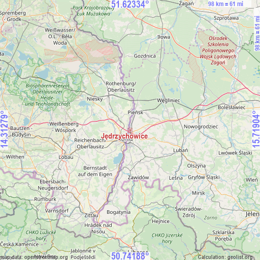
Jędrzychowice GPS coordinates[2]
51° 11' 4.992" North, 15° 0' 57.276" East
| Map corner | latitude | longitude |
|---|---|---|
| Upper-left | 51.62334°, | 14.31279° |
| Center: | 51.18472°, | 15.01591° |
| Lower-right: | 50.74188°, | 15.71904° |
| Map W x H: | 98×98 km | = 60.9×60.9mi |
| max Lat: | 54.83135° ⇑49.5% North |
| Jędrzychowice: | 51.18472° |
| min Lat: | ⇓50.5% South 49.21328° |
| min Long | Jędrzychowice | max Long |
| 14.20249° | 15.01591° | 24.03723° |
| W 2.1%⇐ | ⇒97.9% E |
Elevation
Elevation of Jędrzychowice is 188 m = 617 ft, and this is 3.4 m = 11 ft below average elevation for this country.
| Max E: |
974 m = 3196 ft | 44% |
| Avg. | 191.4 m = 628 ft | |
| Jędrzychowice | 188 m = 617 ft | |
Min E: |
-3 m = -10 ft | 56% |
See also: Poland elevation on elevation.city.
Geographical zone
Jędrzychowice is located in North temperate zone (between Tropic of Cancer and the Arctic Circle). Distance of this North polar circle is 1710 km =1062.5 mi to North.| Distance of | km | miles | from Jędrzychowice |
|---|---|---|---|
| North Pole | 4315.9 | 2681.8 | to North |
| Arctic Circle | 1710 | 1062.5 | to North |
| Tropic Cancer | 3085.3 | 1917.1 | to South |
| Equator | 5691.2 | 3536.3 | to South |


Nearby cities:
15 places around Jędrzychowice: (largest is in red/bold)
• Bogatynia
31.1 km =19.3 mi,  187°
187°
• Gozdnica
28.6 km =17.8 mi,  11°
11°
• Leśna
24.9 km =15.5 mi,  135°
135°
• Lubań
20.3 km =12.6 mi,  110°
110°
• Nowogrodziec
26.7 km =16.6 mi,  87°
87°
• Olszyna
28.1 km =17.5 mi,  117°
117°
• Pieńsk
7.5 km =4.7 mi,  16°
16°
• Pisarzowice
15.6 km =9.7 mi, 106°
• Platerówka
17.6 km =10.9 mi, 141°
• Siekierczyn
14.2 km =8.8 mi, 119°
• Sulików
12.6 km =7.8 mi,  163°
163°
• Węgliniec
18.7 km =11.6 mi,  52°
52°
• Zawidów
18 km =11.2 mi,  169°
169°
• Zgorzelec
4 km =2.5 mi, 187°
• Łagów
3.5 km =2.2 mi,  146°
146°
Sources, notices
• [Note1] Compared only with cities in Poland existing in our database
• [Src1] Map data: © OpenStreetMap contributors (CC-BY-SA)
• [Src2] Other city data from geonames.org with taken over terms of usage.
• [Src3] Geographical zone / Annual Mean Temperature by Robert A. Rohde @ Wikipedia
