Zgorzelec geodata
Zgorzelec (Lower Silesia) is a seat of a second-order administrative division; located in Poland in Europe/Warsaw (GMT+2) time zone. With population of 33,247 people, there are 156 cities with bigger population in this country. Compared to other cities in Poland, 50.3% of cities are located further ↑North; 98% of cities are located further →East and 65.9% of cities have lower elevation than Zgorzelec. Note1


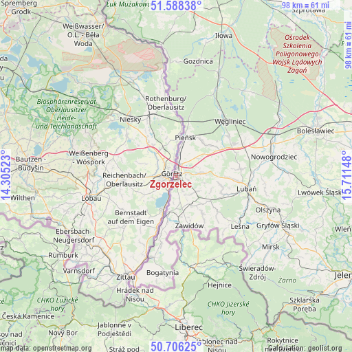
Zgorzelec GPS coordinates[2]
51° 8' 57.912" North, 15° 0' 30.06" East
| Map corner | latitude | longitude |
|---|---|---|
| Upper-left | 51.58838°, | 14.30523° |
| Center: | 51.14942°, | 15.00835° |
| Lower-right: | 50.70625°, | 15.71148° |
| Map W x H: | 98.1×98.1 km | = 61×61mi |
| max Lat: | 54.83135° ⇑50.3% North |
| Zgorzelec: | 51.14942° |
| min Lat: | ⇓49.7% South 49.21328° |
| min Long | Zgorzelec | max Long |
| 14.20249° | 15.00835° | 24.03723° |
| W 2%⇐ | ⇒98% E |
Elevation
Elevation of Zgorzelec is 216 m = 709 ft, and this is 24.6 m = 81 ft above average elevation for this country.
| Max E: |
974 m = 3196 ft | 34.1% |
| Zgorzelec | 216 m 709 ft | |
| Avg. | 191.4 m = 628 ft | |
Min E: |
-3 m = -10 ft | 65.9% |
See also: Poland elevation on elevation.city.
Geographical zone
Zgorzelec is located in North temperate zone (between Tropic of Cancer and the Arctic Circle). Distance of this North polar circle is 1713.9 km =1065 mi to North.| Distance of | km | miles | from Zgorzelec |
|---|---|---|---|
| North Pole | 4319.8 | 2684.2 | to North |
| Arctic Circle | 1713.9 | 1065 | to North |
| Tropic Cancer | 3081.4 | 1914.7 | to South |
| Equator | 5687.3 | 3533.9 | to South |


Nearby cities:
15 places around Zgorzelec: (largest is in red/bold)
• Bogatynia
27.1 km =16.8 mi,  187°
187°
• Gryfów Śląski
31.6 km =19.6 mi,  114°
114°
• Jędrzychowice
4 km =2.5 mi,  7°
7°
• Leśna
22.6 km =14 mi,  127°
127°
• Lubań
19.8 km =12.3 mi,  99°
99°
• Nowogrodziec
27.7 km =17.2 mi,  79°
79°
• Olszyna
27 km =16.8 mi, 109°
• Pieńsk
11.4 km =7.1 mi, 13°
• Pisarzowice
15.5 km =9.6 mi,  91°
91°
• Platerówka
15.2 km =9.4 mi, 131°
• Siekierczyn
13.3 km =8.3 mi, 103°
• Sulików
9.1 km =5.7 mi,  152°
152°
• Węgliniec
21.7 km =13.5 mi,  45°
45°
• Zawidów
14.3 km =8.9 mi,  164°
164°
• Łagów
2.7 km =1.7 mi,  68°
68°
Sources, notices
• [Note1] Compared only with cities in Poland existing in our database
• [Src1] Map data: © OpenStreetMap contributors (CC-BY-SA)
• [Src2] Other city data from geonames.org with taken over terms of usage.
• [Src3] Geographical zone / Annual Mean Temperature by Robert A. Rohde @ Wikipedia
