Jasienica geodata
Jasienica (Lesser Poland) is a populated place; located in Poland in Europe/Warsaw (GMT+2) time zone. With population of 1,500 people, there are 1837 cities with bigger population in this country. Compared to other cities in Poland, 90.9% of cities are located further ↑North; 55.8% of cities are located further ←West and 92.2% of cities have lower elevation than Jasienica. Note1


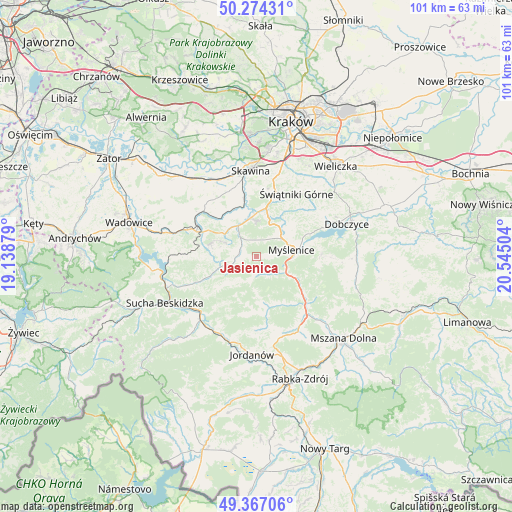
Jasienica GPS coordinates[2]
49° 49' 22.116" North, 19° 50' 30.876" East
| Map corner | latitude | longitude |
|---|---|---|
| Upper-left | 50.27431°, | 19.13879° |
| Center: | 49.82281°, | 19.84191° |
| Lower-right: | 49.36706°, | 20.54504° |
| Map W x H: | 100.9×100.9 km | = 62.7×62.7mi |
| max Lat: | 54.83135° ⇑90.9% North |
| Jasienica: | 49.82281° |
| min Lat: | ⇓9.1% South 49.21328° |
| min Long | Jasienica | max Long |
| 14.20249° | 19.84191° | 24.03723° |
| W 55.8%⇐ | ⇒44.2% E |
Elevation
Elevation of Jasienica is 360 m = 1181 ft, and this is 168.6 m = 553 ft above average elevation for this country.
| Max E: |
974 m = 3196 ft | 7.8% |
| Jasienica | 360 m 1181 ft | |
| Avg. | 191.4 m = 628 ft | |
Min E: |
-3 m = -10 ft | 92.2% |
See also: Poland elevation on elevation.city.
Geographical zone
Jasienica is located in North temperate zone (between Tropic of Cancer and the Arctic Circle). Distance of this North polar circle is 1861.4 km =1156.6 mi to North.| Distance of | km | miles | from Jasienica |
|---|---|---|---|
| North Pole | 4467.3 | 2775.9 | to North |
| Arctic Circle | 1861.4 | 1156.6 | to North |
| Tropic Cancer | 2933.9 | 1823 | to South |
| Equator | 5539.8 | 3442.3 | to South |


Nearby cities:
15 places around Jasienica: (largest is in red/bold)
• Biertowice
6.5 km =4 mi,  327°
327°
• Bieńkówka
7.2 km =4.5 mi,  224°
224°
• Bęczarka
6.4 km =4 mi,  16°
16°
• Harbutowice
4.6 km =2.9 mi,  255°
255°
• Izdebnik
7.6 km =4.7 mi,  316°
316°
• Jastrzębia
6.6 km =4.1 mi,  293°
293°
• Jawornik
5.2 km =3.2 mi,  45°
45°
• Krzywaczka
7.9 km =4.9 mi,  354°
354°
• Myślenice
7 km =4.3 mi,  79°
79°
• Palcza
7.3 km =4.5 mi,  253°
253°
• Polanka
8.2 km =5.1 mi,  58°
58°
• Rudnik
3.3 km =2.1 mi,  6°
6°
• Stróża
6.6 km =4.1 mi,  116°
116°
• Sułkowice
3.5 km =2.2 mi,  303°
303°
• Trzebunia
3.5 km =2.2 mi,  173°
173°
Sources, notices
• [Note1] Compared only with cities in Poland existing in our database
• [Src1] Map data: © OpenStreetMap contributors (CC-BY-SA)
• [Src2] Other city data from geonames.org with taken over terms of usage.
• [Src3] Geographical zone / Annual Mean Temperature by Robert A. Rohde @ Wikipedia
