Biertowice geodata
Biertowice (Lesser Poland) is a populated place; located in Poland in Europe/Warsaw (GMT+2) time zone. With population of 900 people, there are 2674 cities with bigger population in this country. Compared to other cities in Poland, 88.8% of cities are located further ↑North; 54.7% of cities are located further ←West and 78.1% of cities have lower elevation than Biertowice. Note1


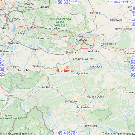
Biertowice GPS coordinates[2]
49° 52' 19.452" North, 19° 47' 34.44" East
| Map corner | latitude | longitude |
|---|---|---|
| Upper-left | 50.32311°, | 19.08978° |
| Center: | 49.87207°, | 19.7929° |
| Lower-right: | 49.41678°, | 20.49603° |
| Map W x H: | 100.8×100.8 km | = 62.6×62.6mi |
| max Lat: | 54.83135° ⇑88.8% North |
| Biertowice: | 49.87207° |
| min Lat: | ⇓11.2% South 49.21328° |
| min Long | Biertowice | max Long |
| 14.20249° | 19.7929° | 24.03723° |
| W 54.7%⇐ | ⇒45.3% E |
Elevation
Elevation of Biertowice is 258 m = 846 ft, and this is 66.6 m = 219 ft above average elevation for this country.
| Max E: |
974 m = 3196 ft | 21.9% |
| Biertowice | 258 m 846 ft | |
| Avg. | 191.4 m = 628 ft | |
Min E: |
-3 m = -10 ft | 78.1% |
See also: Poland elevation on elevation.city.
Geographical zone
Biertowice is located in North temperate zone (between Tropic of Cancer and the Arctic Circle). Distance of this North polar circle is 1855.9 km =1153.2 mi to North.| Distance of | km | miles | from Biertowice |
|---|---|---|---|
| North Pole | 4461.8 | 2772.4 | to North |
| Arctic Circle | 1855.9 | 1153.2 | to North |
| Tropic Cancer | 2939.3 | 1826.4 | to South |
| Equator | 5545.3 | 3445.7 | to South |


Nearby cities:
15 places around Biertowice: (largest is in red/bold)
• Brody
6.9 km =4.3 mi,  265°
265°
• Bęczarka
5.4 km =3.4 mi,  83°
83°
• Głogoczów
6.3 km =3.9 mi,  66°
66°
• Harbutowice
6.7 km =4.2 mi,  187°
187°
• Izdebnik
1.8 km =1.1 mi, 270°
• Jasienica
6.5 km =4 mi,  147°
147°
• Jastrzębia
3.8 km =2.4 mi,  222°
222°
• Krzywaczka
3.7 km =2.3 mi,  49°
49°
• Lanckorona
6.3 km =3.9 mi,  241°
241°
• Leńcze
5.1 km =3.2 mi,  305°
305°
• Radziszów
7.2 km =4.5 mi,  12°
12°
• Rudnik
4.5 km =2.8 mi,  119°
119°
• Sułkowice
3.6 km =2.2 mi,  170°
170°
• Wola Radziszowska
3.7 km =2.3 mi,  354°
354°
• Zarzyce Wielkie
4.6 km =2.9 mi,  283°
283°
Sources, notices
• [Note1] Compared only with cities in Poland existing in our database
• [Src1] Map data: © OpenStreetMap contributors (CC-BY-SA)
• [Src2] Other city data from geonames.org with taken over terms of usage.
• [Src3] Geographical zone / Annual Mean Temperature by Robert A. Rohde @ Wikipedia
