Libiąż geodata
Libiąż (Lesser Poland) is a seat of a third-order administrative division; located in Poland in Europe/Warsaw (GMT+2) time zone. With population of 17,834 people, there are 277 cities with bigger population in this country. Compared to other cities in Poland, 77.8% of cities are located further ↑North; 54.2% of cities are located further →East and 83.9% of cities have lower elevation than Libiąż. Note1


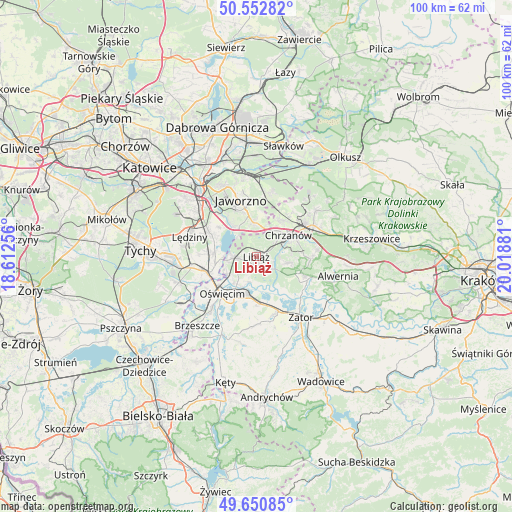
Libiąż GPS coordinates[2]
50° 6' 14.256" North, 19° 18' 56.448" East
| Map corner | latitude | longitude |
|---|---|---|
| Upper-left | 50.55282°, | 18.61256° |
| Center: | 50.10396°, | 19.31568° |
| Lower-right: | 49.65085°, | 20.01881° |
| Map W x H: | 100.3×100.3 km | = 62.3×62.3mi |
| max Lat: | 54.83135° ⇑77.8% North |
| Libiąż: | 50.10396° |
| min Lat: | ⇓22.2% South 49.21328° |
| min Long | Libiąż | max Long |
| 14.20249° | 19.31568° | 24.03723° |
| W 45.8%⇐ | ⇒54.2% E |
Elevation
Elevation of Libiąż is 285 m = 935 ft, and this is 93.6 m = 307 ft above average elevation for this country.
| Max E: |
974 m = 3196 ft | 16.1% |
| Libiąż | 285 m 935 ft | |
| Avg. | 191.4 m = 628 ft | |
Min E: |
-3 m = -10 ft | 83.9% |
See also: Poland elevation on elevation.city.
Geographical zone
Libiąż is located in North temperate zone (between Tropic of Cancer and the Arctic Circle). Distance of this North polar circle is 1830.1 km =1137.2 mi to North.| Distance of | km | miles | from Libiąż |
|---|---|---|---|
| North Pole | 4436 | 2756.4 | to North |
| Arctic Circle | 1830.1 | 1137.2 | to North |
| Tropic Cancer | 2965.1 | 1842.4 | to South |
| Equator | 5571 | 3461.7 | to South |


Nearby cities:
15 places around Libiąż: (largest is in red/bold)
• Babice
9.9 km =6.2 mi,  237°
237°
• Babice
10.3 km =6.4 mi,  112°
112°
• Balin
8.6 km =5.3 mi,  34°
34°
• Chełm Śląski
8.6 km =5.3 mi,  273°
273°
• Chełmek
4.8 km =3 mi, 266°
• Chrzanów
7.1 km =4.4 mi,  60°
60°
• Imielin
10.3 km =6.4 mi,  296°
296°
• Luszowice
10 km =6.2 mi,  38°
38°
• Mętków
7.1 km =4.4 mi,  143°
143°
• Pogorzyce
7.6 km =4.7 mi,  91°
91°
• Poręba Wielka
10.6 km =6.6 mi,  192°
192°
• Płaza
10.6 km =6.6 mi, 92°
• Włosienica
9.5 km =5.9 mi,  179°
179°
• Zagórze
6.4 km =4 mi,  99°
99°
• Żarki
3.5 km =2.2 mi,  132°
132°
Sources, notices
• [Note1] Compared only with cities in Poland existing in our database
• [Src1] Map data: © OpenStreetMap contributors (CC-BY-SA)
• [Src2] Other city data from geonames.org with taken over terms of usage.
• [Src3] Geographical zone / Annual Mean Temperature by Robert A. Rohde @ Wikipedia
