Chałupki geodata
Chałupki (Silesia) is a populated place; located in Poland in Europe/Warsaw (GMT+2) time zone. With population of 1,697 people, there are 1701 cities with bigger population in this country. Compared to other cities in Poland, 86.5% of cities are located further ↑North; 71.1% of cities are located further →East and 60.6% of cities have lower elevation than Chałupki. Note1


Chałupki GPS coordinates[2]
49° 55' 32.124" North, 18° 19' 2.28" East
| Map corner | latitude | longitude |
|---|---|---|
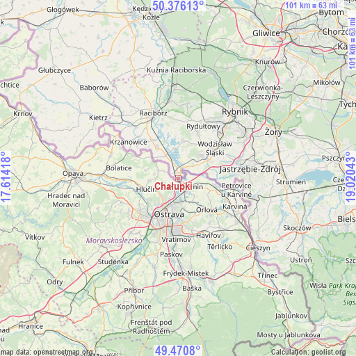
| Upper-left | 50.37613°, | 17.61418° |
| Center: | 49.92559°, | 18.3173° |
| Lower-right: | 49.4708°, | 19.02043° |
| Map W x H: | 100.7×100.7 km | = 62.6×62.6mi |
| max Lat: | 54.83135° ⇑86.5% North |
| Chałupki: | 49.92559° |
| min Lat: | ⇓13.5% South 49.21328° |
| min Long | Chałupki | max Long |
| 14.20249° | 18.3173° | 24.03723° |
| W 28.9%⇐ | ⇒71.1% E |
Elevation
Elevation of Chałupki is 202 m = 663 ft, and this is 10.6 m = 35 ft above average elevation for this country.
| Max E: |
974 m = 3196 ft | 39.4% |
| Chałupki | 202 m 663 ft | |
| Avg. | 191.4 m = 628 ft | |
Min E: |
-3 m = -10 ft | 60.6% |
See also: Poland elevation on elevation.city.
Geographical zone
Chałupki is located in North temperate zone (between Tropic of Cancer and the Arctic Circle). Distance of this North polar circle is 1850 km =1149.5 mi to North.| Distance of | km | miles | from Chałupki |
|---|---|---|---|
| North Pole | 4455.9 | 2768.8 | to North |
| Arctic Circle | 1850 | 1149.5 | to North |
| Tropic Cancer | 2945.3 | 1830.1 | to South |
| Equator | 5551.2 | 3449.4 | to South |


Nearby cities:
15 places around Chałupki: (largest is in red/bold)
• Bełsznica
6.7 km =4.2 mi,  29°
29°
• Czyżowice
9.1 km =5.7 mi,  43°
43°
• Godów
11.5 km =7.1 mi,  90°
90°
• Gorzyce
6.9 km =4.3 mi,  57°
57°
• Gorzyczki
6.7 km =4.2 mi,  66°
66°
• Krzyżanowice
7.2 km =4.5 mi,  331°
331°
• Lubomia
12.7 km =7.9 mi,  357°
357°
• Nieboczowy
13.8 km =8.6 mi,  342°
342°
• Olza
3.5 km =2.2 mi, 26°
• Rogów
7.7 km =4.8 mi,  18°
18°
• Skrzyszów
12.5 km =7.8 mi,  78°
78°
• Syrynia
10.7 km =6.6 mi,  11°
11°
• Turza Śląska
10.1 km =6.3 mi, 58°
• Tworków
10.6 km =6.6 mi, 326°
• Łaziska
9.4 km =5.8 mi, 83°
Sources, notices
• [Note1] Compared only with cities in Poland existing in our database
• [Src1] Map data: © OpenStreetMap contributors (CC-BY-SA)
• [Src2] Other city data from geonames.org with taken over terms of usage.
• [Src3] Geographical zone / Annual Mean Temperature by Robert A. Rohde @ Wikipedia
