Syrynia geodata
Syrynia (Silesia) is a populated place; located in Poland in Europe/Warsaw (GMT+2) time zone. With population of 3,138 people, there are 1005 cities with bigger population in this country. Compared to other cities in Poland, 81.4% of cities are located further ↑North; 70.6% of cities are located further →East and 62.8% of cities have lower elevation than Syrynia. Note1


Syrynia GPS coordinates[2]
50° 1' 12.144" North, 18° 20' 45.492" East
| Map corner | latitude | longitude |
|---|---|---|
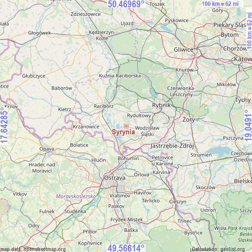
| Upper-left | 50.46969°, | 17.64285° |
| Center: | 50.02004°, | 18.34597° |
| Lower-right: | 49.56614°, | 19.0491° |
| Map W x H: | 100.5×100.5 km | = 62.4×62.4mi |
| max Lat: | 54.83135° ⇑81.4% North |
| Syrynia: | 50.02004° |
| min Lat: | ⇓18.6% South 49.21328° |
| min Long | Syrynia | max Long |
| 14.20249° | 18.34597° | 24.03723° |
| W 29.4%⇐ | ⇒70.6% E |
Elevation
Elevation of Syrynia is 208 m = 682 ft, and this is 16.6 m = 54 ft above average elevation for this country.
| Max E: |
974 m = 3196 ft | 37.2% |
| Syrynia | 208 m 682 ft | |
| Avg. | 191.4 m = 628 ft | |
Min E: |
-3 m = -10 ft | 62.8% |
See also: Poland elevation on elevation.city.
Geographical zone
Syrynia is located in North temperate zone (between Tropic of Cancer and the Arctic Circle). Distance of this North polar circle is 1839.5 km =1143 mi to North.| Distance of | km | miles | from Syrynia |
|---|---|---|---|
| North Pole | 4445.4 | 2762.2 | to North |
| Arctic Circle | 1839.5 | 1143 | to North |
| Tropic Cancer | 2955.8 | 1836.6 | to South |
| Equator | 5561.7 | 3455.9 | to South |


Nearby cities:
15 places around Syrynia: (largest is in red/bold)
• Bełsznica
4.8 km =3 mi,  165°
165°
• Czernica
8.1 km =5 mi,  28°
28°
• Czyżowice
5.7 km =3.5 mi,  133°
133°
• Gorzyce
7.7 km =4.8 mi,  150°
150°
• Kornowac
5.9 km =3.7 mi,  347°
347°
• Krzyżanowice
6.9 km =4.3 mi,  232°
232°
• Lubomia
3.5 km =2.2 mi,  309°
309°
• Nieboczowy
6.7 km =4.2 mi,  292°
292°
• Olza
7.4 km =4.6 mi,  183°
183°
• Pogrzebień
6.2 km =3.9 mi,  327°
327°
• Pszów
4.1 km =2.5 mi,  57°
57°
• Rogów
3.3 km =2.1 mi, 173°
• Rydułtowy
6.6 km =4.1 mi,  49°
49°
• Turza Śląska
8.4 km =5.2 mi, 128°
• Tworków
8 km =5 mi,  258°
258°
Sources, notices
• [Note1] Compared only with cities in Poland existing in our database
• [Src1] Map data: © OpenStreetMap contributors (CC-BY-SA)
• [Src2] Other city data from geonames.org with taken over terms of usage.
• [Src3] Geographical zone / Annual Mean Temperature by Robert A. Rohde @ Wikipedia
