Tworków geodata
Tworków (Silesia) is a populated place; located in Poland in Europe/Warsaw (GMT+2) time zone. With population of 2,800 people, there are 1120 cities with bigger population in this country. Compared to other cities in Poland, 82.2% of cities are located further ↑North; 72% of cities are located further →East and 63% of cities have lower elevation than Tworków. Note1


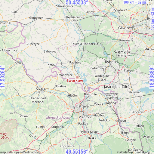
Tworków GPS coordinates[2]
50° 0' 20.124" North, 18° 14' 8.736" East
| Map corner | latitude | longitude |
|---|---|---|
| Upper-left | 50.45538°, | 17.53264° |
| Center: | 50.00559°, | 18.23576° |
| Lower-right: | 49.55156°, | 18.93889° |
| Map W x H: | 100.5×100.5 km | = 62.4×62.4mi |
| max Lat: | 54.83135° ⇑82.2% North |
| Tworków: | 50.00559° |
| min Lat: | ⇓17.8% South 49.21328° |
| min Long | Tworków | max Long |
| 14.20249° | 18.23576° | 24.03723° |
| W 28%⇐ | ⇒72% E |
Elevation
Elevation of Tworków is 209 m = 686 ft, and this is 17.6 m = 58 ft above average elevation for this country.
| Max E: |
974 m = 3196 ft | 37% |
| Tworków | 209 m 686 ft | |
| Avg. | 191.4 m = 628 ft | |
Min E: |
-3 m = -10 ft | 63% |
See also: Poland elevation on elevation.city.
Geographical zone
Tworków is located in North temperate zone (between Tropic of Cancer and the Arctic Circle). Distance of this North polar circle is 1841.1 km =1144 mi to North.| Distance of | km | miles | from Tworków |
|---|---|---|---|
| North Pole | 4447 | 2763.2 | to North |
| Arctic Circle | 1841.1 | 1144 | to North |
| Tropic Cancer | 2954.2 | 1835.7 | to South |
| Equator | 5560.1 | 3454.9 | to South |


Nearby cities:
15 places around Tworków: (largest is in red/bold)
• Bełsznica
9.6 km =6 mi,  108°
108°
• Bojanów
5.6 km =3.5 mi,  297°
297°
• Borucin
5.6 km =3.5 mi,  272°
272°
• Chałupki
10.6 km =6.6 mi,  146°
146°
• Kobyła
10.8 km =6.7 mi,  26°
26°
• Kornowac
9.9 km =6.2 mi,  41°
41°
• Krzanowice
8.2 km =5.1 mi,  279°
279°
• Krzyżanowice
3.5 km =2.2 mi,  137°
137°
• Lubomia
6.4 km =4 mi,  53°
53°
• Nieboczowy
4.6 km =2.9 mi,  21°
21°
• Olza
9.4 km =5.8 mi,  127°
127°
• Pogrzebień
8.2 km =5.1 mi, 33°
• Racibórz
9.7 km =6 mi,  353°
353°
• Rogów
8.4 km =5.2 mi,  101°
101°
• Syrynia
8 km =5 mi,  78°
78°
Sources, notices
• [Note1] Compared only with cities in Poland existing in our database
• [Src1] Map data: © OpenStreetMap contributors (CC-BY-SA)
• [Src2] Other city data from geonames.org with taken over terms of usage.
• [Src3] Geographical zone / Annual Mean Temperature by Robert A. Rohde @ Wikipedia
