Płoty geodata
Płoty (West Pomerania) is a seat of a third-order administrative division; located in Poland in Europe/Warsaw (GMT+2) time zone. With population of 4,093 people, there are 800 cities with bigger population in this country. Compared to other cities in Poland, 92.3% of cities are located further ↓South; 96.6% of cities are located further →East and 95.9% of cities have higher elevation than Płoty. Note1


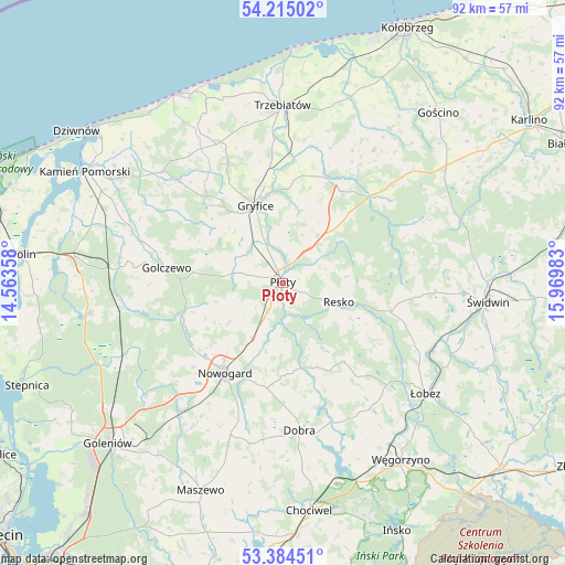
Płoty GPS coordinates[2]
53° 48' 6.552" North, 15° 16' 0.12" East
| Map corner | latitude | longitude |
|---|---|---|
| Upper-left | 54.21502°, | 14.56358° |
| Center: | 53.80182°, | 15.2667° |
| Lower-right: | 53.38451°, | 15.96983° |
| Map W x H: | 92.3×92.3 km | = 57.4×57.4mi |
| max Lat: | 54.83135° ⇑7.7% North |
| Płoty: | 53.80182° |
| min Lat: | ⇓92.3% South 49.21328° |
| min Long | Płoty | max Long |
| 14.20249° | 15.2667° | 24.03723° |
| W 3.4%⇐ | ⇒96.6% E |
Elevation
Elevation of Płoty is 33 m = 108 ft, and this is 158.4 m = 520 ft below average elevation for this country.
| Max E: |
974 m = 3196 ft | 95.9% |
| Avg. | 191.4 m = 628 ft | |
| Płoty | 33 m = 108 ft | |
Min E: |
-3 m = -10 ft | 4.1% |
See also: Poland elevation on elevation.city.
Geographical zone
Płoty is located in North temperate zone (between Tropic of Cancer and the Arctic Circle). Distance of this North polar circle is 1419 km =881.7 mi to North.| Distance of | km | miles | from Płoty |
|---|---|---|---|
| North Pole | 4024.9 | 2501 | to North |
| Arctic Circle | 1419 | 881.7 | to North |
| Tropic Cancer | 3376.3 | 2097.9 | to South |
| Equator | 5982.2 | 3717.2 | to South |


Nearby cities:
15 places around Płoty: (largest is in red/bold)
• Brojce
18.3 km =11.4 mi,  19°
19°
• Cerkwica
25.1 km =15.6 mi,  335°
335°
• Czarnogłowy
23.8 km =14.8 mi,  260°
260°
• Dobra
24.1 km =15 mi,  173°
173°
• Golczewo
19.1 km =11.9 mi,  277°
277°
• Gryfice
13.5 km =8.4 mi, 341°
• Karnice
28.9 km =18 mi,  331°
331°
• Mysłowice
26.2 km =16.3 mi,  66°
66°
• Nowogard
17.3 km =10.7 mi,  214°
214°
• Osina
27.6 km =17.1 mi,  217°
217°
• Radowo Małe
19.3 km =12 mi,  141°
141°
• Resko
9.7 km =6 mi,  109°
109°
• Rymań
23.3 km =14.5 mi,  47°
47°
• Trzebiatów
28.9 km =18 mi,  359°
359°
• Świerzno
26.8 km =16.7 mi,  312°
312°
Sources, notices
• [Note1] Compared only with cities in Poland existing in our database
• [Src1] Map data: © OpenStreetMap contributors (CC-BY-SA)
• [Src2] Other city data from geonames.org with taken over terms of usage.
• [Src3] Geographical zone / Annual Mean Temperature by Robert A. Rohde @ Wikipedia
