Gościno geodata
Gościno (West Pomerania) is a seat of a third-order administrative division; located in Poland in Europe/Warsaw (GMT+2) time zone. With population of 2,636 people, there are 1194 cities with bigger population in this country. Compared to other cities in Poland, 94.7% of cities are located further ↓South; 94.6% of cities are located further →East and 95.1% of cities have higher elevation than Gościno. Note1


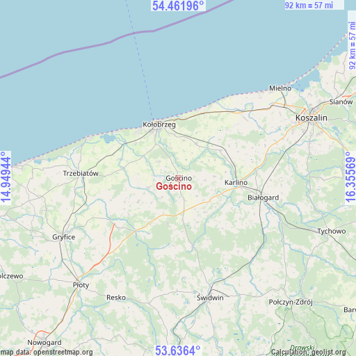
Gościno GPS coordinates[2]
54° 3' 4.428" North, 15° 39' 9.216" East
| Map corner | latitude | longitude |
|---|---|---|
| Upper-left | 54.46196°, | 14.94944° |
| Center: | 54.05123°, | 15.65256° |
| Lower-right: | 53.6364°, | 16.35569° |
| Map W x H: | 91.8×91.8 km | = 57×57mi |
| max Lat: | 54.83135° ⇑5.3% North |
| Gościno: | 54.05123° |
| min Lat: | ⇓94.7% South 49.21328° |
| min Long | Gościno | max Long |
| 14.20249° | 15.65256° | 24.03723° |
| W 5.4%⇐ | ⇒94.6% E |
Elevation
Elevation of Gościno is 40 m = 131 ft, and this is 151.4 m = 497 ft below average elevation for this country.
| Max E: |
974 m = 3196 ft | 95.1% |
| Avg. | 191.4 m = 628 ft | |
| Gościno | 40 m = 131 ft | |
Min E: |
-3 m = -10 ft | 4.9% |
See also: Poland elevation on elevation.city.
Geographical zone
Gościno is located in North temperate zone (between Tropic of Cancer and the Arctic Circle). Distance of this North polar circle is 1391.2 km =864.5 mi to North.| Distance of | km | miles | from Gościno |
|---|---|---|---|
| North Pole | 3997.1 | 2483.7 | to North |
| Arctic Circle | 1391.2 | 864.5 | to North |
| Tropic Cancer | 3404 | 2115.1 | to South |
| Equator | 6009.9 | 3734.4 | to South |


Nearby cities:
15 places around Gościno: (largest is in red/bold)
• Białogard
22.4 km =13.9 mi,  102°
102°
• Brojce
21.8 km =13.5 mi,  241°
241°
• Drzonowo
15 km =9.3 mi,  289°
289°
• Dygowo
9.8 km =6.1 mi,  26°
26°
• Dźwirzyno
19.8 km =12.3 mi,  307°
307°
• Grzybowo
16.2 km =10.1 mi,  317°
317°
• Karlino
14.8 km =9.2 mi, 96°
• Kołobrzeg
14.5 km =9 mi,  341°
341°
• Mrzeżyno
25.7 km =16 mi, 293°
• Mysłowice
17.5 km =10.9 mi,  183°
183°
• Rymań
14.4 km =8.9 mi,  214°
214°
• Siemyśl
8.2 km =5.1 mi,  251°
251°
• Sławoborze
18.3 km =11.4 mi,  168°
168°
• Trzebiatów
25.3 km =15.7 mi,  272°
272°
• Ustronie Morskie
19.4 km =12.1 mi,  20°
20°
Sources, notices
• [Note1] Compared only with cities in Poland existing in our database
• [Src1] Map data: © OpenStreetMap contributors (CC-BY-SA)
• [Src2] Other city data from geonames.org with taken over terms of usage.
• [Src3] Geographical zone / Annual Mean Temperature by Robert A. Rohde @ Wikipedia
