Brenna geodata
Brenna (Silesia) is a seat of a third-order administrative division; located in Poland in Europe/Warsaw (GMT+2) time zone. With population of 5,859 people, there are 616 cities with bigger population in this country. Compared to other cities in Poland, 93.8% of cities are located further ↑North; 61.9% of cities are located further →East and 94.2% of cities have lower elevation than Brenna. Note1


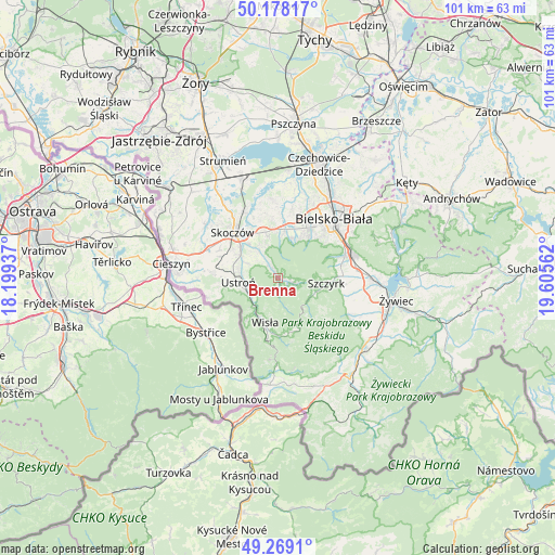
Brenna GPS coordinates[2]
49° 43' 32.736" North, 18° 54' 8.964" East
| Map corner | latitude | longitude |
|---|---|---|
| Upper-left | 50.17817°, | 18.19937° |
| Center: | 49.72576°, | 18.90249° |
| Lower-right: | 49.2691°, | 19.60562° |
| Map W x H: | 101.1×101.1 km | = 62.8×62.8mi |
| max Lat: | 54.83135° ⇑93.8% North |
| Brenna: | 49.72576° |
| min Lat: | ⇓6.2% South 49.21328° |
| min Long | Brenna | max Long |
| 14.20249° | 18.90249° | 24.03723° |
| W 38.1%⇐ | ⇒61.9% E |
Elevation
Elevation of Brenna is 395 m = 1296 ft, and this is 203.6 m = 668 ft above average elevation for this country.
| Max E: |
974 m = 3196 ft | 5.8% |
| Brenna | 395 m 1296 ft | |
| Avg. | 191.4 m = 628 ft | |
Min E: |
-3 m = -10 ft | 94.2% |
See also: Poland elevation on elevation.city.
Geographical zone
Brenna is located in North temperate zone (between Tropic of Cancer and the Arctic Circle). Distance of this North polar circle is 1872.2 km =1163.3 mi to North.| Distance of | km | miles | from Brenna |
|---|---|---|---|
| North Pole | 4478.1 | 2782.6 | to North |
| Arctic Circle | 1872.2 | 1163.3 | to North |
| Tropic Cancer | 2923.1 | 1816.3 | to South |
| Equator | 5529 | 3435.6 | to South |


Nearby cities:
15 places around Brenna: (largest is in red/bold)
• Buczkowice
12 km =7.5 mi,  88°
88°
• Bystra
11.9 km =7.4 mi,  71°
71°
• Bładnice
10.6 km =6.6 mi,  303°
303°
• Cisownica
10.1 km =6.3 mi,  268°
268°
• Górki Małe
5.5 km =3.4 mi,  323°
323°
• Górki Wielkie
7.9 km =4.9 mi, 319°
• Harbutowice
9 km =5.6 mi,  311°
311°
• Jasienica
9.8 km =6.1 mi,  8°
8°
• Jaworze
8.2 km =5.1 mi,  23°
23°
• Miedzyświec
11.8 km =7.3 mi, 303°
• Pogórze
9.2 km =5.7 mi,  332°
332°
• Skoczów
11.7 km =7.3 mi, 315°
• Szczyrk
9.3 km =5.8 mi,  95°
95°
• Ustroń
7.2 km =4.5 mi, 266°
• Wisła
8.3 km =5.2 mi,  202°
202°
Sources, notices
• [Note1] Compared only with cities in Poland existing in our database
• [Src1] Map data: © OpenStreetMap contributors (CC-BY-SA)
• [Src2] Other city data from geonames.org with taken over terms of usage.
• [Src3] Geographical zone / Annual Mean Temperature by Robert A. Rohde @ Wikipedia
