Bładnice geodata
Bładnice (Silesia) is a section of populated place; located in Poland in Europe/Warsaw (GMT+2) time zone. With population of 706 people, there are 3055 cities with bigger population in this country. Compared to other cities in Poland, 92.4% of cities are located further ↑North; 63.7% of cities are located further →East and 87.3% of cities have lower elevation than Bładnice. Note1


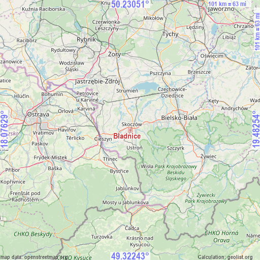
Bładnice GPS coordinates[2]
49° 46' 42.96" North, 18° 46' 45.876" East
| Map corner | latitude | longitude |
|---|---|---|
| Upper-left | 50.23051°, | 18.07629° |
| Center: | 49.7786°, | 18.77941° |
| Lower-right: | 49.32243°, | 19.48254° |
| Map W x H: | 101×101 km | = 62.8×62.8mi |
| max Lat: | 54.83135° ⇑92.4% North |
| Bładnice: | 49.7786° |
| min Lat: | ⇓7.6% South 49.21328° |
| min Long | Bładnice | max Long |
| 14.20249° | 18.77941° | 24.03723° |
| W 36.3%⇐ | ⇒63.7% E |
Elevation
Elevation of Bładnice is 304 m = 997 ft, and this is 112.6 m = 369 ft above average elevation for this country.
| Max E: |
974 m = 3196 ft | 12.7% |
| Bładnice | 304 m 997 ft | |
| Avg. | 191.4 m = 628 ft | |
Min E: |
-3 m = -10 ft | 87.3% |
See also: Poland elevation on elevation.city.
Geographical zone
Bładnice is located in North temperate zone (between Tropic of Cancer and the Arctic Circle). Distance of this North polar circle is 1866.3 km =1159.7 mi to North.| Distance of | km | miles | from Bładnice |
|---|---|---|---|
| North Pole | 4472.2 | 2778.9 | to North |
| Arctic Circle | 1866.3 | 1159.7 | to North |
| Tropic Cancer | 2928.9 | 1819.9 | to South |
| Equator | 5534.9 | 3439.2 | to South |


Nearby cities:
15 places around Bładnice: (largest is in red/bold)
• Cisownica
6.3 km =3.9 mi,  191°
191°
• Dębowiec
5.8 km =3.6 mi,  313°
313°
• Goleszów
5.7 km =3.5 mi,  212°
212°
• Górki Małe
5.8 km =3.6 mi,  104°
104°
• Górki Wielkie
3.7 km =2.3 mi,  88°
88°
• Harbutowice
2.1 km =1.3 mi, 87°
• Iskrzyczyn
3.2 km =2 mi, 307°
• Kiczyce
5.4 km =3.4 mi,  17°
17°
• Kostkowice
5.9 km =3.7 mi,  287°
287°
• Miedzyświec
1.2 km =0.7 mi,  300°
300°
• Ogrodzona
3.8 km =2.4 mi,  251°
251°
• Pogórze
5.1 km =3.2 mi,  62°
62°
• Simoradz
3.9 km =2.4 mi,  339°
339°
• Skoczów
2.5 km =1.6 mi,  13°
13°
• Wiślica
4.7 km =2.9 mi,  3°
3°
Sources, notices
• [Note1] Compared only with cities in Poland existing in our database
• [Src1] Map data: © OpenStreetMap contributors (CC-BY-SA)
• [Src2] Other city data from geonames.org with taken over terms of usage.
• [Src3] Geographical zone / Annual Mean Temperature by Robert A. Rohde @ Wikipedia
