Skoczów geodata
Skoczów (Silesia) is a seat of a third-order administrative division; located in Poland in Europe/Warsaw (GMT+2) time zone. With population of 14,810 people, there are 339 cities with bigger population in this country. Compared to other cities in Poland, 91.7% of cities are located further ↑North; 63.5% of cities are located further →East and 85.6% of cities have lower elevation than Skoczów. Note1


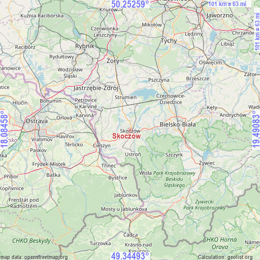
Skoczów GPS coordinates[2]
49° 48' 3.204" North, 18° 47' 15.72" East
| Map corner | latitude | longitude |
|---|---|---|
| Upper-left | 50.25259°, | 18.08458° |
| Center: | 49.80089°, | 18.7877° |
| Lower-right: | 49.34493°, | 19.49083° |
| Map W x H: | 100.9×100.9 km | = 62.7×62.7mi |
| max Lat: | 54.83135° ⇑91.7% North |
| Skoczów: | 49.80089° |
| min Lat: | ⇓8.3% South 49.21328° |
| min Long | Skoczów | max Long |
| 14.20249° | 18.7877° | 24.03723° |
| W 36.5%⇐ | ⇒63.5% E |
Elevation
Elevation of Skoczów is 293 m = 961 ft, and this is 101.6 m = 333 ft above average elevation for this country.
| Max E: |
974 m = 3196 ft | 14.4% |
| Skoczów | 293 m 961 ft | |
| Avg. | 191.4 m = 628 ft | |
Min E: |
-3 m = -10 ft | 85.6% |
See also: Poland elevation on elevation.city.
Geographical zone
Skoczów is located in North temperate zone (between Tropic of Cancer and the Arctic Circle). Distance of this North polar circle is 1863.8 km =1158.1 mi to North.| Distance of | km | miles | from Skoczów |
|---|---|---|---|
| North Pole | 4469.7 | 2777.3 | to North |
| Arctic Circle | 1863.8 | 1158.1 | to North |
| Tropic Cancer | 2931.4 | 1821.5 | to South |
| Equator | 5537.3 | 3440.7 | to South |


Nearby cities:
15 places around Skoczów: (largest is in red/bold)
• Bładnice
2.5 km =1.6 mi,  193°
193°
• Dębowiec
5 km =3.1 mi,  286°
286°
• Górki Wielkie
3.9 km =2.4 mi,  127°
127°
• Harbutowice
2.8 km =1.7 mi,  148°
148°
• Iskrzyczyn
3.2 km =2 mi,  260°
260°
• Kiczyce
2.9 km =1.8 mi,  21°
21°
• Kostkowice
6.2 km =3.9 mi, 263°
• Kowale
4.7 km =2.9 mi,  53°
53°
• Miedzyświec
2.5 km =1.6 mi,  221°
221°
• Ochaby
4.8 km =3 mi,  343°
343°
• Ogrodzona
5.6 km =3.5 mi,  229°
229°
• Pierściec
4.1 km =2.5 mi,  27°
27°
• Pogórze
4 km =2.5 mi,  92°
92°
• Simoradz
2.3 km =1.4 mi,  301°
301°
• Wiślica
2.3 km =1.4 mi,  351°
351°
Sources, notices
• [Note1] Compared only with cities in Poland existing in our database
• [Src1] Map data: © OpenStreetMap contributors (CC-BY-SA)
• [Src2] Other city data from geonames.org with taken over terms of usage.
• [Src3] Geographical zone / Annual Mean Temperature by Robert A. Rohde @ Wikipedia
