Pogórze geodata
Pogórze (Silesia) is a populated place; located in Poland in Europe/Warsaw (GMT+2) time zone. With population of 1,851 people, there are 1582 cities with bigger population in this country. Compared to other cities in Poland, 91.8% of cities are located further ↑North; 62.7% of cities are located further →East and 90.7% of cities have lower elevation than Pogórze. Note1


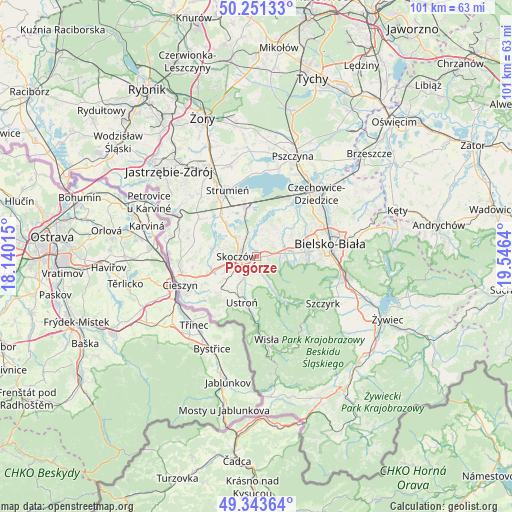
Pogórze GPS coordinates[2]
49° 47' 58.596" North, 18° 50' 35.772" East
| Map corner | latitude | longitude |
|---|---|---|
| Upper-left | 50.25133°, | 18.14015° |
| Center: | 49.79961°, | 18.84327° |
| Lower-right: | 49.34364°, | 19.5464° |
| Map W x H: | 100.9×100.9 km | = 62.7×62.7mi |
| max Lat: | 54.83135° ⇑91.8% North |
| Pogórze: | 49.79961° |
| min Lat: | ⇓8.2% South 49.21328° |
| min Long | Pogórze | max Long |
| 14.20249° | 18.84327° | 24.03723° |
| W 37.3%⇐ | ⇒62.7% E |
Elevation
Elevation of Pogórze is 339 m = 1112 ft, and this is 147.6 m = 484 ft above average elevation for this country.
| Max E: |
974 m = 3196 ft | 9.3% |
| Pogórze | 339 m 1112 ft | |
| Avg. | 191.4 m = 628 ft | |
Min E: |
-3 m = -10 ft | 90.7% |
See also: Poland elevation on elevation.city.
Geographical zone
Pogórze is located in North temperate zone (between Tropic of Cancer and the Arctic Circle). Distance of this North polar circle is 1864 km =1158.2 mi to North.| Distance of | km | miles | from Pogórze |
|---|---|---|---|
| North Pole | 4469.9 | 2777.5 | to North |
| Arctic Circle | 1864 | 1158.2 | to North |
| Tropic Cancer | 2931.3 | 1821.4 | to South |
| Equator | 5537.2 | 3440.7 | to South |


Nearby cities:
15 places around Pogórze: (largest is in red/bold)
• Bładnice
5.1 km =3.2 mi,  242°
242°
• Górki Małe
3.9 km =2.4 mi,  165°
165°
• Górki Wielkie
2.4 km =1.5 mi,  201°
201°
• Harbutowice
3.4 km =2.1 mi,  228°
228°
• Iskrzyczyn
7.1 km =4.4 mi,  266°
266°
• Jasienica
5.8 km =3.6 mi,  75°
75°
• Jaworze
7.5 km =4.7 mi,  95°
95°
• Kiczyce
4 km =2.5 mi,  313°
313°
• Kowale
3 km =1.9 mi,  355°
355°
• Miedzyświec
5.9 km =3.7 mi,  253°
253°
• Ochaby
7.2 km =4.5 mi, 311°
• Pierściec
4.3 km =2.7 mi,  330°
330°
• Simoradz
6.1 km =3.8 mi,  282°
282°
• Skoczów
4 km =2.5 mi, 272°
• Wiślica
4.9 km =3 mi,  298°
298°
Sources, notices
• [Note1] Compared only with cities in Poland existing in our database
• [Src1] Map data: © OpenStreetMap contributors (CC-BY-SA)
• [Src2] Other city data from geonames.org with taken over terms of usage.
• [Src3] Geographical zone / Annual Mean Temperature by Robert A. Rohde @ Wikipedia
