Witkowo geodata
Witkowo (Kujawsko-Pomorskie) is a populated place; located in Poland in Europe/Warsaw (GMT+2) time zone. With population of 514 people, there are 3506 cities with bigger population in this country. Compared to other cities in Poland, 80.3% of cities are located further ↓South; 56.5% of cities are located further →East and 81.2% of cities have higher elevation than Witkowo. Note1


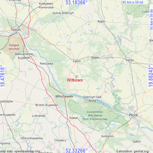
Witkowo GPS coordinates[2]
52° 45' 36.864" North, 19° 10' 45.48" East
| Map corner | latitude | longitude |
|---|---|---|
| Upper-left | 53.18366°, | 18.47618° |
| Center: | 52.76024°, | 19.1793° |
| Lower-right: | 52.33266°, | 19.88243° |
| Map W x H: | 94.6×94.6 km | = 58.8×58.8mi |
| max Lat: | 54.83135° ⇑19.7% North |
| Witkowo: | 52.76024° |
| min Lat: | ⇓80.3% South 49.21328° |
| min Long | Witkowo | max Long |
| 14.20249° | 19.1793° | 24.03723° |
| W 43.5%⇐ | ⇒56.5% E |
Elevation
Elevation of Witkowo is 97 m = 318 ft, and this is 94.4 m = 310 ft below average elevation for this country.
| Max E: |
974 m = 3196 ft | 81.2% |
| Avg. | 191.4 m = 628 ft | |
| Witkowo | 97 m = 318 ft | |
Min E: |
-3 m = -10 ft | 18.8% |
See also: Poland elevation on elevation.city.
Geographical zone
Witkowo is located in North temperate zone (between Tropic of Cancer and the Arctic Circle). Distance of this North polar circle is 1534.8 km =953.7 mi to North.| Distance of | km | miles | from Witkowo |
|---|---|---|---|
| North Pole | 4140.7 | 2572.9 | to North |
| Arctic Circle | 1534.8 | 953.7 | to North |
| Tropic Cancer | 3260.5 | 2026 | to South |
| Equator | 5866.4 | 3645.2 | to South |


Nearby cities:
15 places around Witkowo: (largest is in red/bold)
• Bobrowniki
14.9 km =9.3 mi,  278°
278°
• Brudzeń Duży
24.1 km =15 mi,  114°
114°
• Chrostkowo
21 km =13 mi,  13°
13°
• Dobrzyń nad Wisłą
16.5 km =10.3 mi,  145°
145°
• Fabianki
6.5 km =4 mi,  225°
225°
• Kikół
17.1 km =10.6 mi,  346°
346°
• Lipno
9.4 km =5.8 mi,  359°
359°
• Lubanie
17.6 km =10.9 mi,  265°
265°
• Lubin
20.2 km =12.6 mi, 346°
• Nieszawa
20.6 km =12.8 mi,  293°
293°
• Skępe
16.9 km =10.5 mi,  44°
44°
• Tłuchowo
19.3 km =12 mi,  94°
94°
• Waganiec
20.9 km =13 mi, 282°
• Wielgie
6.1 km =3.8 mi, 110°
• Włocławek
14.6 km =9.1 mi,  211°
211°
Sources, notices
• [Note1] Compared only with cities in Poland existing in our database
• [Src1] Map data: © OpenStreetMap contributors (CC-BY-SA)
• [Src2] Other city data from geonames.org with taken over terms of usage.
• [Src3] Geographical zone / Annual Mean Temperature by Robert A. Rohde @ Wikipedia
