Bliżyce geodata
Bliżyce (Silesia) is a populated place; located in Poland in Europe/Warsaw (GMT+2) time zone. With population of 594 people, there are 3298 cities with bigger population in this country. Compared to other cities in Poland, 64.4% of cities are located further ↑North; 50.1% of cities are located further →East and 90.9% of cities have lower elevation than Bliżyce. Note1


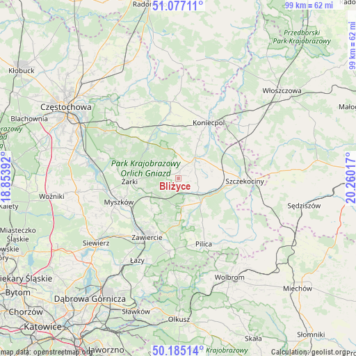
Bliżyce GPS coordinates[2]
50° 37' 59.664" North, 19° 33' 25.344" East
| Map corner | latitude | longitude |
|---|---|---|
| Upper-left | 51.07711°, | 18.85392° |
| Center: | 50.63324°, | 19.55704° |
| Lower-right: | 50.18514°, | 20.26017° |
| Map W x H: | 99.2×99.2 km | = 61.6×61.6mi |
| max Lat: | 54.83135° ⇑64.4% North |
| Bliżyce: | 50.63324° |
| min Lat: | ⇓35.6% South 49.21328° |
| min Long | Bliżyce | max Long |
| 14.20249° | 19.55704° | 24.03723° |
| W 49.9%⇐ | ⇒50.1% E |
Elevation
Elevation of Bliżyce is 342 m = 1122 ft, and this is 150.6 m = 494 ft above average elevation for this country.
| Max E: |
974 m = 3196 ft | 9.1% |
| Bliżyce | 342 m 1122 ft | |
| Avg. | 191.4 m = 628 ft | |
Min E: |
-3 m = -10 ft | 90.9% |
See also: Poland elevation on elevation.city.
Geographical zone
Bliżyce is located in North temperate zone (between Tropic of Cancer and the Arctic Circle). Distance of this North polar circle is 1771.3 km =1100.6 mi to North.| Distance of | km | miles | from Bliżyce |
|---|---|---|---|
| North Pole | 4377.2 | 2719.9 | to North |
| Arctic Circle | 1771.3 | 1100.6 | to North |
| Tropic Cancer | 3024 | 1879 | to South |
| Equator | 5629.9 | 3498.3 | to South |


Nearby cities:
15 places around Bliżyce: (largest is in red/bold)
• Drochlin
12.1 km =7.5 mi,  28°
28°
• Dąbrowno
4.4 km =2.7 mi,  345°
345°
• Góra Włodowska
9.9 km =6.2 mi,  230°
230°
• Irządze
9 km =5.6 mi,  94°
94°
• Janów
13.3 km =8.3 mi,  318°
318°
• Jaworznik
10.9 km =6.8 mi,  255°
255°
• Kroczyce
8 km =5 mi,  173°
173°
• Lelów
7.4 km =4.6 mi,  40°
40°
• Nakło
12.2 km =7.6 mi,  77°
77°
• Niegowa
5.2 km =3.2 mi,  279°
279°
• Potok Złoty
12.1 km =7.5 mi,  312°
312°
• Sokolniki
2.9 km =1.8 mi, 76°
• Włodowice
11.4 km =7.1 mi,  220°
220°
• Zdów
3.8 km =2.4 mi,  212°
212°
• Żarki
13.7 km =8.5 mi,  266°
266°
Sources, notices
• [Note1] Compared only with cities in Poland existing in our database
• [Src1] Map data: © OpenStreetMap contributors (CC-BY-SA)
• [Src2] Other city data from geonames.org with taken over terms of usage.
• [Src3] Geographical zone / Annual Mean Temperature by Robert A. Rohde @ Wikipedia
