Kroczyce geodata
Kroczyce (Silesia) is a populated place; located in Poland in Europe/Warsaw (GMT+2) time zone. With population of 1,699 people, there are 1699 cities with bigger population in this country. Compared to other cities in Poland, 66.2% of cities are located further ↑North; 50.2% of cities are located further ←West and 88.9% of cities have lower elevation than Kroczyce. Note1


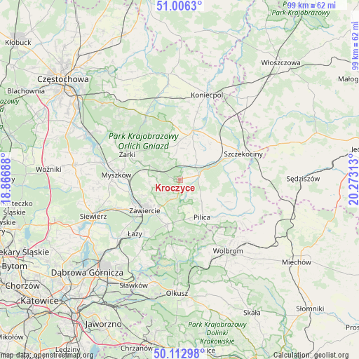
Kroczyce GPS coordinates[2]
50° 33' 42.336" North, 19° 34' 12" East
| Map corner | latitude | longitude |
|---|---|---|
| Upper-left | 51.0063°, | 18.86688° |
| Center: | 50.56176°, | 19.57° |
| Lower-right: | 50.11298°, | 20.27313° |
| Map W x H: | 99.3×99.3 km | = 61.7×61.7mi |
| max Lat: | 54.83135° ⇑66.2% North |
| Kroczyce: | 50.56176° |
| min Lat: | ⇓33.8% South 49.21328° |
| min Long | Kroczyce | max Long |
| 14.20249° | 19.57° | 24.03723° |
| W 50.2%⇐ | ⇒49.8% E |
Elevation
Elevation of Kroczyce is 316 m = 1037 ft, and this is 124.6 m = 409 ft above average elevation for this country.
| Max E: |
974 m = 3196 ft | 11.1% |
| Kroczyce | 316 m 1037 ft | |
| Avg. | 191.4 m = 628 ft | |
Min E: |
-3 m = -10 ft | 88.9% |
See also: Poland elevation on elevation.city.
Geographical zone
Kroczyce is located in North temperate zone (between Tropic of Cancer and the Arctic Circle). Distance of this North polar circle is 1779.2 km =1105.5 mi to North.| Distance of | km | miles | from Kroczyce |
|---|---|---|---|
| North Pole | 4385.1 | 2724.8 | to North |
| Arctic Circle | 1779.2 | 1105.5 | to North |
| Tropic Cancer | 3016 | 1874.1 | to South |
| Equator | 5621.9 | 3493.3 | to South |


Nearby cities:
15 places around Kroczyce: (largest is in red/bold)
• Bliżyce
8 km =5 mi,  353°
353°
• Dąbrowno
12.4 km =7.7 mi, 350°
• Góra Włodowska
8.8 km =5.5 mi,  280°
280°
• Irządze
10.9 km =6.8 mi,  48°
48°
• Jaworznik
12.6 km =7.8 mi,  294°
294°
• Lelów
14.1 km =8.8 mi,  16°
16°
• Nakło
15.2 km =9.4 mi, 46°
• Niegowa
10.7 km =6.6 mi,  325°
325°
• Ogrodzieniec
12.7 km =7.9 mi,  196°
196°
• Pilica
12.1 km =7.5 mi,  149°
149°
• Rudniki
10.8 km =6.7 mi,  245°
245°
• Sokolniki
8.8 km =5.5 mi,  12°
12°
• Włodowice
8.4 km =5.2 mi,  265°
265°
• Zawiercie
13.6 km =8.5 mi,  232°
232°
• Zdów
5.6 km =3.5 mi, 327°
Sources, notices
• [Note1] Compared only with cities in Poland existing in our database
• [Src1] Map data: © OpenStreetMap contributors (CC-BY-SA)
• [Src2] Other city data from geonames.org with taken over terms of usage.
• [Src3] Geographical zone / Annual Mean Temperature by Robert A. Rohde @ Wikipedia
