Niegowa geodata
Niegowa (Silesia) is a populated place; located in Poland in Europe/Warsaw (GMT+2) time zone. With population of 775 people, there are 2916 cities with bigger population in this country. Compared to other cities in Poland, 64.1% of cities are located further ↑North; 51.2% of cities are located further →East and 91.6% of cities have lower elevation than Niegowa. Note1


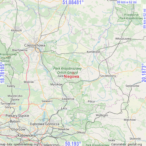
Niegowa GPS coordinates[2]
50° 38' 27.672" North, 19° 29' 3.012" East
| Map corner | latitude | longitude |
|---|---|---|
| Upper-left | 51.08481°, | 18.78105° |
| Center: | 50.64102°, | 19.48417° |
| Lower-right: | 50.193°, | 20.1873° |
| Map W x H: | 99.2×99.2 km | = 61.6×61.6mi |
| max Lat: | 54.83135° ⇑64.1% North |
| Niegowa: | 50.64102° |
| min Lat: | ⇓35.9% South 49.21328° |
| min Long | Niegowa | max Long |
| 14.20249° | 19.48417° | 24.03723° |
| W 48.8%⇐ | ⇒51.2% E |
Elevation
Elevation of Niegowa is 351 m = 1152 ft, and this is 159.6 m = 524 ft above average elevation for this country.
| Max E: |
974 m = 3196 ft | 8.4% |
| Niegowa | 351 m 1152 ft | |
| Avg. | 191.4 m = 628 ft | |
Min E: |
-3 m = -10 ft | 91.6% |
See also: Poland elevation on elevation.city.
Geographical zone
Niegowa is located in North temperate zone (between Tropic of Cancer and the Arctic Circle). Distance of this North polar circle is 1770.4 km =1100.1 mi to North.| Distance of | km | miles | from Niegowa |
|---|---|---|---|
| North Pole | 4376.3 | 2719.3 | to North |
| Arctic Circle | 1770.4 | 1100.1 | to North |
| Tropic Cancer | 3024.8 | 1879.5 | to South |
| Equator | 5630.8 | 3498.8 | to South |


Nearby cities:
15 places around Niegowa: (largest is in red/bold)
• Bliżyce
5.2 km =3.2 mi,  99°
99°
• Dąbrowno
5.3 km =3.3 mi,  49°
49°
• Góra Włodowska
7.6 km =4.7 mi,  199°
199°
• Janów
9.8 km =6.1 mi,  338°
338°
• Jaworznik
6.5 km =4 mi,  236°
236°
• Kroczyce
10.7 km =6.6 mi,  145°
145°
• Lelów
11 km =6.8 mi,  64°
64°
• Potok Złoty
8.2 km =5.1 mi,  332°
332°
• Przybynów
11.8 km =7.3 mi,  276°
276°
• Siedlec
10.2 km =6.3 mi,  304°
304°
• Sokolniki
8 km =5 mi,  91°
91°
• Wysoka Lelowska
10.3 km =6.4 mi,  266°
266°
• Włodowice
9.8 km =6.1 mi,  193°
193°
• Zdów
5.1 km =3.2 mi,  143°
143°
• Żarki
8.7 km =5.4 mi,  258°
258°
Sources, notices
• [Note1] Compared only with cities in Poland existing in our database
• [Src1] Map data: © OpenStreetMap contributors (CC-BY-SA)
• [Src2] Other city data from geonames.org with taken over terms of usage.
• [Src3] Geographical zone / Annual Mean Temperature by Robert A. Rohde @ Wikipedia
