Potok Złoty geodata
Potok Złoty (Silesia) is a populated place; located in Poland in Europe/Warsaw (GMT+2) time zone. With population of 1,101 people, there are 2304 cities with bigger population in this country. Compared to other cities in Poland, 62.5% of cities are located further ↑North; 52.2% of cities are located further →East and 84.4% of cities have lower elevation than Potok Złoty. Note1


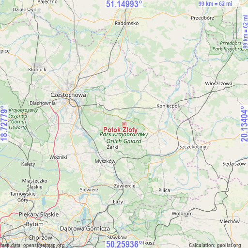
Potok Złoty GPS coordinates[2]
50° 42' 24.336" North, 19° 25' 51.276" East
| Map corner | latitude | longitude |
|---|---|---|
| Upper-left | 51.14993°, | 18.72779° |
| Center: | 50.70676°, | 19.43091° |
| Lower-right: | 50.25936°, | 20.13404° |
| Map W x H: | 99×99 km | = 61.5×61.5mi |
| max Lat: | 54.83135° ⇑62.5% North |
| Potok Złoty: | 50.70676° |
| min Lat: | ⇓37.5% South 49.21328° |
| min Long | Potok Złoty | max Long |
| 14.20249° | 19.43091° | 24.03723° |
| W 47.8%⇐ | ⇒52.2% E |
Elevation
Elevation of Potok Złoty is 287 m = 942 ft, and this is 95.6 m = 314 ft above average elevation for this country.
| Max E: |
974 m = 3196 ft | 15.6% |
| Potok Złoty | 287 m 942 ft | |
| Avg. | 191.4 m = 628 ft | |
Min E: |
-3 m = -10 ft | 84.4% |
See also: Poland elevation on elevation.city.
Geographical zone
Potok Złoty is located in North temperate zone (between Tropic of Cancer and the Arctic Circle). Distance of this North polar circle is 1763.1 km =1095.5 mi to North.| Distance of | km | miles | from Potok Złoty |
|---|---|---|---|
| North Pole | 4369 | 2714.8 | to North |
| Arctic Circle | 1763.1 | 1095.5 | to North |
| Tropic Cancer | 3032.1 | 1884.1 | to South |
| Equator | 5638.1 | 3503.4 | to South |


Nearby cities:
15 places around Potok Złoty: (largest is in red/bold)
• Bliżyce
12.1 km =7.5 mi,  132°
132°
• Choroń
12.3 km =7.6 mi,  256°
256°
• Dąbrowno
8.7 km =5.4 mi,  116°
116°
• Janów
1.8 km =1.1 mi,  3°
3°
• Jaworznik
11 km =6.8 mi,  188°
188°
• Lelów
14 km =8.7 mi,  100°
100°
• Niegowa
8.2 km =5.1 mi,  152°
152°
• Olsztyn
12.6 km =7.8 mi,  293°
293°
• Przybynów
10 km =6.2 mi,  233°
233°
• Przyrów
12.5 km =7.8 mi,  33°
33°
• Siedlec
4.9 km =3 mi,  252°
252°
• Sokolniki
13.9 km =8.6 mi, 122°
• Wysoka Lelowska
10.3 km =6.4 mi,  219°
219°
• Zdów
13.3 km =8.3 mi, 149°
• Żarki
10.2 km =6.3 mi,  207°
207°
Sources, notices
• [Note1] Compared only with cities in Poland existing in our database
• [Src1] Map data: © OpenStreetMap contributors (CC-BY-SA)
• [Src2] Other city data from geonames.org with taken over terms of usage.
• [Src3] Geographical zone / Annual Mean Temperature by Robert A. Rohde @ Wikipedia
