Lelów geodata
Lelów (Silesia) is a populated place; located in Poland in Europe/Warsaw (GMT+2) time zone. With population of 2,127 people, there are 1398 cities with bigger population in this country. Compared to other cities in Poland, 63% of cities are located further ↑North; 51.3% of cities are located further ←West and 77.9% of cities have lower elevation than Lelów. Note1


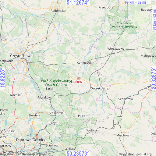
Lelów GPS coordinates[2]
50° 41' 0.06" North, 19° 37' 32.232" East
| Map corner | latitude | longitude |
|---|---|---|
| Upper-left | 51.12674°, | 18.9225° |
| Center: | 50.68335°, | 19.62562° |
| Lower-right: | 50.23573°, | 20.32875° |
| Map W x H: | 99.1×99.1 km | = 61.6×61.6mi |
| max Lat: | 54.83135° ⇑63% North |
| Lelów: | 50.68335° |
| min Lat: | ⇓37% South 49.21328° |
| min Long | Lelów | max Long |
| 14.20249° | 19.62562° | 24.03723° |
| W 51.3%⇐ | ⇒48.7% E |
Elevation
Elevation of Lelów is 257 m = 843 ft, and this is 65.6 m = 215 ft above average elevation for this country.
| Max E: |
974 m = 3196 ft | 22.1% |
| Lelów | 257 m 843 ft | |
| Avg. | 191.4 m = 628 ft | |
Min E: |
-3 m = -10 ft | 77.9% |
See also: Poland elevation on elevation.city.
Geographical zone
Lelów is located in North temperate zone (between Tropic of Cancer and the Arctic Circle). Distance of this North polar circle is 1765.7 km =1097.2 mi to North.| Distance of | km | miles | from Lelów |
|---|---|---|---|
| North Pole | 4371.6 | 2716.4 | to North |
| Arctic Circle | 1765.7 | 1097.2 | to North |
| Tropic Cancer | 3029.5 | 1882.4 | to South |
| Equator | 5635.5 | 3501.7 | to South |


Nearby cities:
15 places around Lelów: (largest is in red/bold)
• Bliżyce
7.4 km =4.6 mi,  220°
220°
• Drochlin
5.2 km =3.2 mi,  10°
10°
• Dąbrowno
6.1 km =3.8 mi,  257°
257°
• Irządze
7.6 km =4.7 mi,  146°
146°
• Janów
14.3 km =8.9 mi,  288°
288°
• Koniecpol
11.1 km =6.9 mi,  23°
23°
• Kroczyce
14.1 km =8.8 mi,  196°
196°
• Nakło
7.7 km =4.8 mi,  113°
113°
• Niegowa
11 km =6.8 mi,  244°
244°
• Potok Złoty
14 km =8.7 mi,  280°
280°
• Przyrów
14.7 km =9.1 mi,  332°
332°
• Psary
14.9 km =9.3 mi,  69°
69°
• Sokolniki
5.3 km =3.3 mi, 202°
• Szczekociny
15.4 km =9.6 mi, 114°
• Zdów
11.2 km =7 mi, 218°
Sources, notices
• [Note1] Compared only with cities in Poland existing in our database
• [Src1] Map data: © OpenStreetMap contributors (CC-BY-SA)
• [Src2] Other city data from geonames.org with taken over terms of usage.
• [Src3] Geographical zone / Annual Mean Temperature by Robert A. Rohde @ Wikipedia
