Będzin geodata
Będzin (Silesia) is a seat of a second-order administrative division; located in Poland in Europe/Warsaw (GMT+2) time zone. With population of 58,236 people, there are 89 cities with bigger population in this country. Compared to other cities in Poland, 71.3% of cities are located further ↑North; 57.7% of cities are located further →East and 77.2% of cities have lower elevation than Będzin. Note1


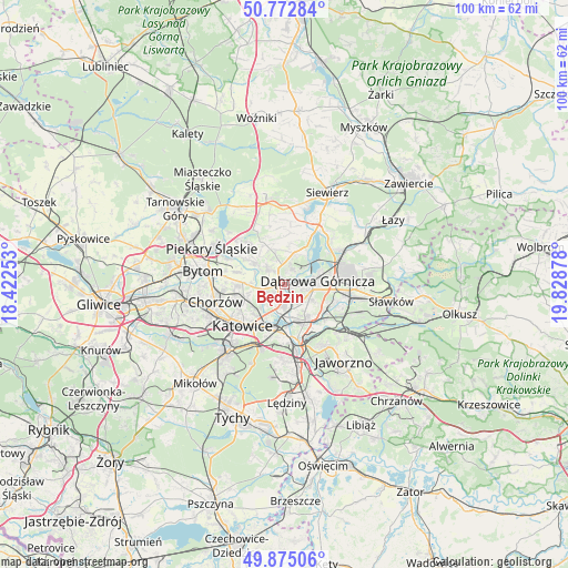
Będzin GPS coordinates[2]
50° 19' 33.852" North, 19° 7' 32.34" East
| Map corner | latitude | longitude |
|---|---|---|
| Upper-left | 50.77284°, | 18.42253° |
| Center: | 50.32607°, | 19.12565° |
| Lower-right: | 49.87506°, | 19.82878° |
| Map W x H: | 99.8×99.8 km | = 62×62mi |
| max Lat: | 54.83135° ⇑71.3% North |
| Będzin: | 50.32607° |
| min Lat: | ⇓28.7% South 49.21328° |
| min Long | Będzin | max Long |
| 14.20249° | 19.12565° | 24.03723° |
| W 42.3%⇐ | ⇒57.7% E |
Elevation
Elevation of Będzin is 255 m = 837 ft, and this is 63.6 m = 209 ft above average elevation for this country.
| Max E: |
974 m = 3196 ft | 22.8% |
| Będzin | 255 m 837 ft | |
| Avg. | 191.4 m = 628 ft | |
Min E: |
-3 m = -10 ft | 77.2% |
See also: Będzin elevation on elevation.city.
Geographical zone
Będzin is located in North temperate zone (between Tropic of Cancer and the Arctic Circle). Distance of this North polar circle is 1805.4 km =1121.8 mi to North.| Distance of | km | miles | from Będzin |
|---|---|---|---|
| North Pole | 4411.3 | 2741.1 | to North |
| Arctic Circle | 1805.4 | 1121.8 | to North |
| Tropic Cancer | 2989.8 | 1857.8 | to South |
| Equator | 5595.7 | 3477 | to South |


Nearby cities:
15 places around Będzin: (largest is in red/bold)
• Bobrowniki
11.5 km =7.1 mi,  301°
301°
• Brzeziny Śląskie
10.7 km =6.6 mi,  287°
287°
• Chorzów
11 km =6.8 mi,  258°
258°
• Czeladź
3.6 km =2.2 mi,  250°
250°
• Dobieszowice
11.2 km =7 mi,  314°
314°
• Dąbrowa Górnicza
5.7 km =3.5 mi,  81°
81°
• Gródków
4.3 km =2.7 mi,  340°
340°
• Katowice
10.3 km =6.4 mi,  222°
222°
• Psary
6 km =3.7 mi,  353°
353°
• Rogoźnik
9.5 km =5.9 mi,  319°
319°
• Sarnów
5.6 km =3.5 mi,  18°
18°
• Siemianowice Śląskie
6.9 km =4.3 mi,  271°
271°
• Sosnowiec
4.6 km =2.9 mi,  199°
199°
• Strzyżowice
7.5 km =4.7 mi,  334°
334°
• Wojkowice
7.7 km =4.8 mi, 304°
Sources, notices
• [Note1] Compared only with cities in Poland existing in our database
• [Src1] Map data: © OpenStreetMap contributors (CC-BY-SA)
• [Src2] Other city data from geonames.org with taken over terms of usage.
• [Src3] Geographical zone / Annual Mean Temperature by Robert A. Rohde @ Wikipedia
