Rogoźnik geodata
Rogoźnik (Silesia) is a populated place; located in Poland in Europe/Warsaw (GMT+2) time zone. With population of 2,753 people, there are 1144 cities with bigger population in this country. Compared to other cities in Poland, 69.6% of cities are located further ↑North; 59.4% of cities are located further →East and 87.1% of cities have lower elevation than Rogoźnik. Note1


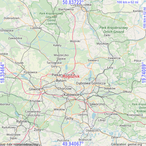
Rogoźnik GPS coordinates[2]
50° 23' 27.816" North, 19° 2' 15.936" East
| Map corner | latitude | longitude |
|---|---|---|
| Upper-left | 50.83722°, | 18.33464° |
| Center: | 50.39106°, | 19.03776° |
| Lower-right: | 49.94067°, | 19.74089° |
| Map W x H: | 99.7×99.7 km | = 62×62mi |
| max Lat: | 54.83135° ⇑69.6% North |
| Rogoźnik: | 50.39106° |
| min Lat: | ⇓30.4% South 49.21328° |
| min Long | Rogoźnik | max Long |
| 14.20249° | 19.03776° | 24.03723° |
| W 40.6%⇐ | ⇒59.4% E |
Elevation
Elevation of Rogoźnik is 301 m = 988 ft, and this is 109.6 m = 360 ft above average elevation for this country.
| Max E: |
974 m = 3196 ft | 12.9% |
| Rogoźnik | 301 m 988 ft | |
| Avg. | 191.4 m = 628 ft | |
Min E: |
-3 m = -10 ft | 87.1% |
See also: Poland elevation on elevation.city.
Geographical zone
Rogoźnik is located in North temperate zone (between Tropic of Cancer and the Arctic Circle). Distance of this North polar circle is 1798.2 km =1117.3 mi to North.| Distance of | km | miles | from Rogoźnik |
|---|---|---|---|
| North Pole | 4404.1 | 2736.6 | to North |
| Arctic Circle | 1798.2 | 1117.3 | to North |
| Tropic Cancer | 2997 | 1862.2 | to South |
| Equator | 5603 | 3481.5 | to South |


Nearby cities:
15 places around Rogoźnik: (largest is in red/bold)
• Bobrowniki
3.8 km =2.4 mi,  251°
251°
• Brzeziny Śląskie
5.7 km =3.5 mi,  224°
224°
• Bytom
8.8 km =5.5 mi,  237°
237°
• Dobieszowice
1.9 km =1.2 mi,  290°
290°
• Gródków
5.8 km =3.6 mi,  123°
123°
• Mierzęcice
8.8 km =5.5 mi,  47°
47°
• Ożarowice
7.9 km =4.9 mi,  2°
2°
• Piekary Śląskie
8 km =5 mi,  261°
261°
• Psary
5.7 km =3.5 mi,  102°
102°
• Sarnów
8.2 km =5.1 mi, 103°
• Siemianowice Śląskie
7.1 km =4.4 mi,  185°
185°
• Strzyżowice
3.1 km =1.9 mi, 97°
• Sączów
4.9 km =3 mi,  353°
353°
• Wojkowice
2.9 km =1.8 mi,  181°
181°
• Wymysłów
4.2 km =2.6 mi,  301°
301°
Sources, notices
• [Note1] Compared only with cities in Poland existing in our database
• [Src1] Map data: © OpenStreetMap contributors (CC-BY-SA)
• [Src2] Other city data from geonames.org with taken over terms of usage.
• [Src3] Geographical zone / Annual Mean Temperature by Robert A. Rohde @ Wikipedia
