Dobieszowice geodata
Dobieszowice (Silesia) is a populated place; located in Poland in Europe/Warsaw (GMT+2) time zone. With population of 1,891 people, there are 1566 cities with bigger population in this country. Compared to other cities in Poland, 69.5% of cities are located further ↑North; 59.8% of cities are located further →East and 83.4% of cities have lower elevation than Dobieszowice. Note1


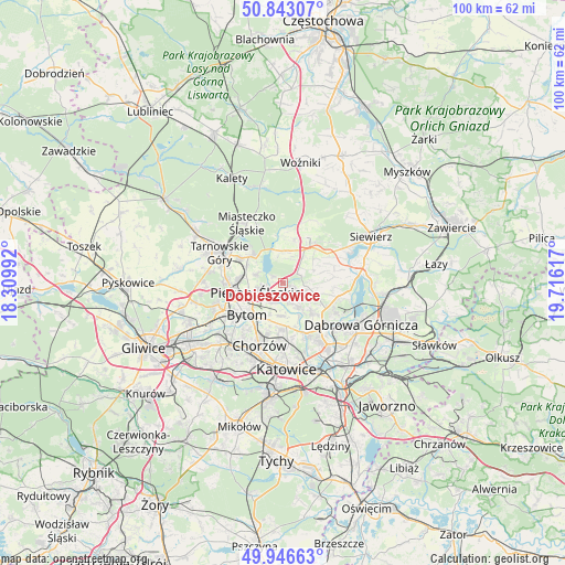
Dobieszowice GPS coordinates[2]
50° 23' 49.092" North, 19° 0' 46.944" East
| Map corner | latitude | longitude |
|---|---|---|
| Upper-left | 50.84307°, | 18.30992° |
| Center: | 50.39697°, | 19.01304° |
| Lower-right: | 49.94663°, | 19.71617° |
| Map W x H: | 99.7×99.7 km | = 62×62mi |
| max Lat: | 54.83135° ⇑69.5% North |
| Dobieszowice: | 50.39697° |
| min Lat: | ⇓30.5% South 49.21328° |
| min Long | Dobieszowice | max Long |
| 14.20249° | 19.01304° | 24.03723° |
| W 40.2%⇐ | ⇒59.8% E |
Elevation
Elevation of Dobieszowice is 282 m = 925 ft, and this is 90.6 m = 297 ft above average elevation for this country.
| Max E: |
974 m = 3196 ft | 16.6% |
| Dobieszowice | 282 m 925 ft | |
| Avg. | 191.4 m = 628 ft | |
Min E: |
-3 m = -10 ft | 83.4% |
See also: Poland elevation on elevation.city.
Geographical zone
Dobieszowice is located in North temperate zone (between Tropic of Cancer and the Arctic Circle). Distance of this North polar circle is 1797.6 km =1117 mi to North.| Distance of | km | miles | from Dobieszowice |
|---|---|---|---|
| North Pole | 4403.4 | 2736.1 | to North |
| Arctic Circle | 1797.6 | 1117 | to North |
| Tropic Cancer | 2997.7 | 1862.7 | to South |
| Equator | 5603.6 | 3481.9 | to South |


Nearby cities:
15 places around Dobieszowice: (largest is in red/bold)
• Bobrowniki
2.7 km =1.7 mi,  224°
224°
• Brzeziny Śląskie
5.2 km =3.2 mi,  205°
205°
• Bytom
7.9 km =4.9 mi,  226°
226°
• Gródków
7.6 km =4.7 mi,  120°
120°
• Orzech
7.2 km =4.5 mi,  297°
297°
• Ożarowice
7.5 km =4.7 mi,  16°
16°
• Piekary Śląskie
6.4 km =4 mi,  253°
253°
• Psary
7.5 km =4.7 mi,  104°
104°
• Rogoźnik
1.9 km =1.2 mi,  110°
110°
• Siemianowice Śląskie
7.8 km =4.8 mi,  171°
171°
• Strzyżowice
4.9 km =3 mi, 102°
• Sączów
4.4 km =2.7 mi, 16°
• Wojkowice
3.9 km =2.4 mi,  154°
154°
• Wymysłów
2.4 km =1.5 mi,  309°
309°
• Świerklaniec
7.4 km =4.6 mi, 313°
Sources, notices
• [Note1] Compared only with cities in Poland existing in our database
• [Src1] Map data: © OpenStreetMap contributors (CC-BY-SA)
• [Src2] Other city data from geonames.org with taken over terms of usage.
• [Src3] Geographical zone / Annual Mean Temperature by Robert A. Rohde @ Wikipedia
