Bobrowniki geodata
Bobrowniki (Silesia) is a seat of a third-order administrative division; located in Poland in Europe/Warsaw (GMT+2) time zone. With population of 2,926 people, there are 1080 cities with bigger population in this country. Compared to other cities in Poland, 70% of cities are located further ↑North; 60.2% of cities are located further →East and 82.8% of cities have lower elevation than Bobrowniki. Note1


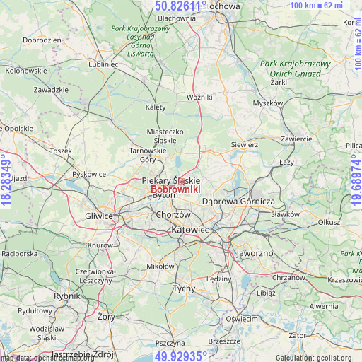
Bobrowniki GPS coordinates[2]
50° 22' 47.46" North, 18° 59' 11.796" East
| Map corner | latitude | longitude |
|---|---|---|
| Upper-left | 50.82611°, | 18.28349° |
| Center: | 50.37985°, | 18.98661° |
| Lower-right: | 49.92935°, | 19.68974° |
| Map W x H: | 99.7×99.7 km | = 62×62mi |
| max Lat: | 54.83135° ⇑70% North |
| Bobrowniki: | 50.37985° |
| min Lat: | ⇓30% South 49.21328° |
| min Long | Bobrowniki | max Long |
| 14.20249° | 18.98661° | 24.03723° |
| W 39.8%⇐ | ⇒60.2% E |
Elevation
Elevation of Bobrowniki is 279 m = 915 ft, and this is 87.6 m = 287 ft above average elevation for this country.
| Max E: |
974 m = 3196 ft | 17.2% |
| Bobrowniki | 279 m 915 ft | |
| Avg. | 191.4 m = 628 ft | |
Min E: |
-3 m = -10 ft | 82.8% |
See also: Poland elevation on elevation.city.
Geographical zone
Bobrowniki is located in North temperate zone (between Tropic of Cancer and the Arctic Circle). Distance of this North polar circle is 1799.5 km =1118.2 mi to North.| Distance of | km | miles | from Bobrowniki |
|---|---|---|---|
| North Pole | 4405.3 | 2737.3 | to North |
| Arctic Circle | 1799.5 | 1118.2 | to North |
| Tropic Cancer | 2995.8 | 1861.5 | to South |
| Equator | 5601.7 | 3480.7 | to South |


Nearby cities:
15 places around Bobrowniki: (largest is in red/bold)
• Brzeziny Śląskie
2.9 km =1.8 mi,  187°
187°
• Bytom
5.2 km =3.2 mi,  227°
227°
• Chorzów
8.3 km =5.2 mi, 186°
• Dobieszowice
2.7 km =1.7 mi,  44°
44°
• Nakło
8.3 km =5.2 mi,  319°
319°
• Orzech
7 km =4.3 mi, 319°
• Piekary Śląskie
4.3 km =2.7 mi,  270°
270°
• Radzionków
6.4 km =4 mi,  290°
290°
• Rogoźnik
3.8 km =2.4 mi,  71°
71°
• Siemianowice Śląskie
6.6 km =4.1 mi,  152°
152°
• Strzyżowice
6.7 km =4.2 mi,  82°
82°
• Sączów
6.9 km =4.3 mi,  26°
26°
• Wojkowice
3.9 km =2.4 mi,  114°
114°
• Wymysłów
3.5 km =2.2 mi,  0°
0°
• Świerklaniec
7.8 km =4.8 mi,  333°
333°
Sources, notices
• [Note1] Compared only with cities in Poland existing in our database
• [Src1] Map data: © OpenStreetMap contributors (CC-BY-SA)
• [Src2] Other city data from geonames.org with taken over terms of usage.
• [Src3] Geographical zone / Annual Mean Temperature by Robert A. Rohde @ Wikipedia
