Gródków geodata
Gródków (Silesia) is a populated place; located in Poland in Europe/Warsaw (GMT+2) time zone. With population of 901 people, there are 2671 cities with bigger population in this country. Compared to other cities in Poland, 70.5% of cities are located further ↑North; 58.2% of cities are located further →East and 86.6% of cities have lower elevation than Gródków. Note1


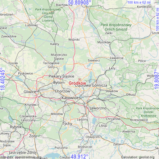
Gródków GPS coordinates[2]
50° 21' 45.576" North, 19° 6' 20.052" East
| Map corner | latitude | longitude |
|---|---|---|
| Upper-left | 50.80908°, | 18.40245° |
| Center: | 50.36266°, | 19.10557° |
| Lower-right: | 49.912°, | 19.8087° |
| Map W x H: | 99.7×99.7 km | = 62×62mi |
| max Lat: | 54.83135° ⇑70.5% North |
| Gródków: | 50.36266° |
| min Lat: | ⇓29.5% South 49.21328° |
| min Long | Gródków | max Long |
| 14.20249° | 19.10557° | 24.03723° |
| W 41.8%⇐ | ⇒58.2% E |
Elevation
Elevation of Gródków is 299 m = 981 ft, and this is 107.6 m = 353 ft above average elevation for this country.
| Max E: |
974 m = 3196 ft | 13.4% |
| Gródków | 299 m 981 ft | |
| Avg. | 191.4 m = 628 ft | |
Min E: |
-3 m = -10 ft | 86.6% |
See also: Poland elevation on elevation.city.
Geographical zone
Gródków is located in North temperate zone (between Tropic of Cancer and the Arctic Circle). Distance of this North polar circle is 1801.4 km =1119.3 mi to North.| Distance of | km | miles | from Gródków |
|---|---|---|---|
| North Pole | 4407.3 | 2738.6 | to North |
| Arctic Circle | 1801.4 | 1119.3 | to North |
| Tropic Cancer | 2993.9 | 1860.3 | to South |
| Equator | 5599.8 | 3479.6 | to South |


Nearby cities:
15 places around Gródków: (largest is in red/bold)
• Bobrowniki
8.7 km =5.4 mi,  282°
282°
• Brzeziny Śląskie
8.9 km =5.5 mi,  264°
264°
• Będzin
4.3 km =2.7 mi,  160°
160°
• Czeladź
5.6 km =3.5 mi,  200°
200°
• Dobieszowice
7.6 km =4.7 mi,  300°
300°
• Dąbrowa Górnicza
7.7 km =4.8 mi,  114°
114°
• Mierzęcice
9.3 km =5.8 mi,  10°
10°
• Psary
2 km =1.2 mi,  20°
20°
• Rogoźnik
5.8 km =3.6 mi, 303°
• Sarnów
3.4 km =2.1 mi,  68°
68°
• Siemianowice Śląskie
6.7 km =4.2 mi,  234°
234°
• Sosnowiec
8.4 km =5.2 mi,  180°
180°
• Strzyżowice
3.3 km =2.1 mi,  326°
326°
• Sączów
9.7 km =6 mi, 326°
• Wojkowice
4.9 km =3 mi,  273°
273°
Sources, notices
• [Note1] Compared only with cities in Poland existing in our database
• [Src1] Map data: © OpenStreetMap contributors (CC-BY-SA)
• [Src2] Other city data from geonames.org with taken over terms of usage.
• [Src3] Geographical zone / Annual Mean Temperature by Robert A. Rohde @ Wikipedia
