Karłowice geodata
Karłowice (Lower Silesia) is a section of populated place; located in Poland in Europe/Warsaw (GMT+2) time zone. With population of 12,651 people, there are 377 cities with bigger population in this country. Compared to other cities in Poland, 51% of cities are located further ↑North; 83.9% of cities are located further →East and 73.5% of cities have higher elevation than Karłowice. Note1
Administrative division(s):
- Level 1: Lower Silesia
- Level 2: Wrocław
- Level 3: Wrocław
- Level 4: Karłowice - Różanka


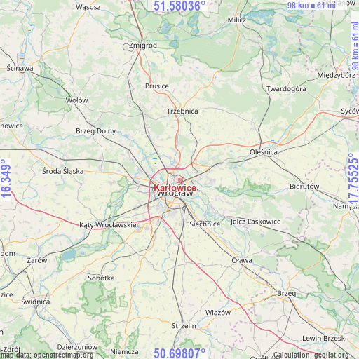
Karłowice GPS coordinates[2]
51° 8' 28.752" North, 17° 3' 7.632" East
| Map corner | latitude | longitude |
|---|---|---|
| Upper-left | 51.58036°, | 16.349° |
| Center: | 51.14132°, | 17.05212° |
| Lower-right: | 50.69807°, | 17.75525° |
| Map W x H: | 98.1×98.1 km | = 61×61mi |
| max Lat: | 54.83135° ⇑51% North |
| Karłowice: | 51.14132° |
| min Lat: | ⇓49% South 49.21328° |
| min Long | Karłowice | max Long |
| 14.20249° | 17.05212° | 24.03723° |
| W 16.1%⇐ | ⇒83.9% E |
Elevation
Elevation of Karłowice is 114 m = 374 ft, and this is 77.4 m = 254 ft below average elevation for this country.
| Max E: |
974 m = 3196 ft | 73.5% |
| Avg. | 191.4 m = 628 ft | |
| Karłowice | 114 m = 374 ft | |
Min E: |
-3 m = -10 ft | 26.5% |
See also: Poland elevation on elevation.city.
Geographical zone
Karłowice is located in North temperate zone (between Tropic of Cancer and the Arctic Circle). Distance of this North polar circle is 1714.8 km =1065.5 mi to North.| Distance of | km | miles | from Karłowice |
|---|---|---|---|
| North Pole | 4320.7 | 2684.8 | to North |
| Arctic Circle | 1714.8 | 1065.5 | to North |
| Tropic Cancer | 3080.5 | 1914.1 | to South |
| Equator | 5686.4 | 3533.4 | to South |


Nearby cities:
15 places around Karłowice: (largest is in red/bold)
• Kowale-Popiele
3.7 km =2.3 mi,  108°
108°
• Pawłowice-Kłokoczyce
4.2 km =2.6 mi,  50°
50°
• Poświętne
2.4 km =1.5 mi,  317°
317°
• Psie Pole Północ
4.2 km =2.6 mi,  71°
71°
• Rejon alei Kromera
1.6 km =1 mi,  122°
122°
• Rejon placu Grunwaldzkiego
2.8 km =1.7 mi,  166°
166°
• Rejon placu Świętego Macieja
2.5 km =1.6 mi,  203°
203°
• Rejon ulicy Klęczkowskiej
1.8 km =1.1 mi,  224°
224°
• Rejon ulicy Traugutta
4.3 km =2.7 mi,  183°
183°
• Różanka-Polanka
2.3 km =1.4 mi,  275°
275°
• Sołtysowice
1.8 km =1.1 mi, 45°
• Szczytniki
3.7 km =2.3 mi,  148°
148°
• Widawa-Lipa Piotrowska-Polanowice
3.9 km =2.4 mi,  327°
327°
• Zacisze
2.6 km =1.6 mi,  142°
142°
• Zalesie i Stadion
3.7 km =2.3 mi,  130°
130°
Sources, notices
• [Note1] Compared only with cities in Poland existing in our database
• [Src1] Map data: © OpenStreetMap contributors (CC-BY-SA)
• [Src2] Other city data from geonames.org with taken over terms of usage.
• [Src3] Geographical zone / Annual Mean Temperature by Robert A. Rohde @ Wikipedia
