Psary geodata
Psary (Lower Silesia) is a populated place; located in Poland in Europe/Warsaw (GMT+2) time zone. With population of 1,018 people, there are 2434 cities with bigger population in this country. Compared to other cities in Poland, 50.5% of cities are located further ↓South; 84.3% of cities are located further →East and 74% of cities have higher elevation than Psary. Note1


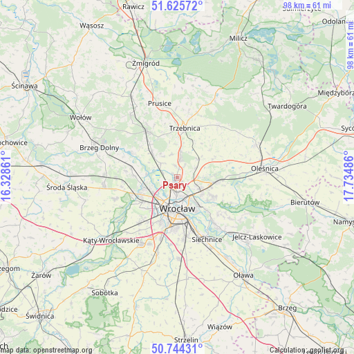
Psary GPS coordinates[2]
51° 11' 13.632" North, 17° 1' 54.228" East
| Map corner | latitude | longitude |
|---|---|---|
| Upper-left | 51.62572°, | 16.32861° |
| Center: | 51.18712°, | 17.03173° |
| Lower-right: | 50.74431°, | 17.73486° |
| Map W x H: | 98×98 km | = 60.9×60.9mi |
| max Lat: | 54.83135° ⇑49.5% North |
| Psary: | 51.18712° |
| min Lat: | ⇓50.5% South 49.21328° |
| min Long | Psary | max Long |
| 14.20249° | 17.03173° | 24.03723° |
| W 15.7%⇐ | ⇒84.3% E |
Elevation
Elevation of Psary is 113 m = 371 ft, and this is 78.4 m = 257 ft below average elevation for this country.
| Max E: |
974 m = 3196 ft | 74% |
| Avg. | 191.4 m = 628 ft | |
| Psary | 113 m = 371 ft | |
Min E: |
-3 m = -10 ft | 26% |
See also: Poland elevation on elevation.city.
Geographical zone
Psary is located in North temperate zone (between Tropic of Cancer and the Arctic Circle). Distance of this North polar circle is 1709.7 km =1062.4 mi to North.| Distance of | km | miles | from Psary |
|---|---|---|---|
| North Pole | 4315.6 | 2681.6 | to North |
| Arctic Circle | 1709.7 | 1062.4 | to North |
| Tropic Cancer | 3085.6 | 1917.3 | to South |
| Equator | 5691.5 | 3536.5 | to South |


Nearby cities:
15 places around Psary: (largest is in red/bold)
• Karłowice
5.3 km =3.3 mi,  164°
164°
• Kozanów
6.4 km =4 mi,  222°
222°
• Maślice Małe
7.5 km =4.7 mi,  236°
236°
• Pawłowice-Kłokoczyce
5.2 km =3.2 mi,  118°
118°
• Pilczyce
7.6 km =4.7 mi, 222°
• Poświętne
3.4 km =2.1 mi,  183°
183°
• Psie Pole Północ
6.6 km =4.1 mi, 124°
• Rejon alei Kromera
6.5 km =4 mi, 155°
• Rejon placu Świętego Macieja
7.4 km =4.6 mi, 176°
• Rejon ulicy Klęczkowskiej
6.4 km =4 mi, 178°
• Różanka-Polanka
4.9 km =3 mi,  189°
189°
• Sołtysowice
4.7 km =2.9 mi,  144°
144°
• Widawa-Lipa Piotrowska-Polanowice
1.9 km =1.2 mi,  201°
201°
• Wisznia Mała
6.8 km =4.2 mi,  7°
7°
• Zakrzów
7.7 km =4.8 mi,  107°
107°
Sources, notices
• [Note1] Compared only with cities in Poland existing in our database
• [Src1] Map data: © OpenStreetMap contributors (CC-BY-SA)
• [Src2] Other city data from geonames.org with taken over terms of usage.
• [Src3] Geographical zone / Annual Mean Temperature by Robert A. Rohde @ Wikipedia
