Pawłowice-Kłokoczyce geodata
Pawłowice-Kłokoczyce (Lower Silesia) is a section of populated place; located in Poland in Europe/Warsaw (GMT+2) time zone. With population of 2,568 people, there are 1217 cities with bigger population in this country. Compared to other cities in Poland, 50.1% of cities are located further ↓South; 83.3% of cities are located further →East and 71.6% of cities have higher elevation than Pawłowice-Kłokoczyce. Note1
Administrative division(s):
- Level 1: Lower Silesia
- Level 2: Wrocław
- Level 3: Wrocław
- Level 4: Pawłowice


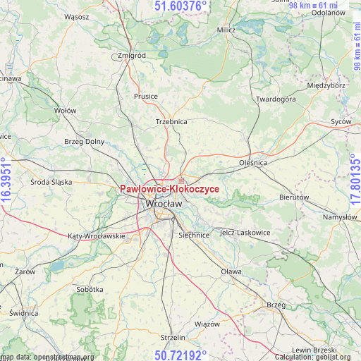
Pawłowice-Kłokoczyce GPS coordinates[2]
51° 9' 53.82" North, 17° 5' 53.592" East
| Map corner | latitude | longitude |
|---|---|---|
| Upper-left | 51.60376°, | 16.3951° |
| Center: | 51.16495°, | 17.09822° |
| Lower-right: | 50.72192°, | 17.80135° |
| Map W x H: | 98.1×98 km | = 61×60.9mi |
| max Lat: | 54.83135° ⇑49.9% North |
| Pawłowice-Kłokoczyce: | 51.16495° |
| min Lat: | ⇓50.1% South 49.21328° |
| min Long | Pawłowice-Kło | max Long |
| 14.20249° | 17.09822° | 24.03723° |
| W 16.7%⇐ | ⇒83.3% E |
Elevation
Elevation of Pawłowice-Kłokoczyce is 118 m = 387 ft, and this is 73.4 m = 241 ft below average elevation for this country.
| Max E: |
974 m = 3196 ft | 71.6% |
| Avg. | 191.4 m = 628 ft | |
| Pawłowice-Kłokoczyce | 118 m = 387 ft | |
Min E: |
-3 m = -10 ft | 28.4% |
See also: Poland elevation on elevation.city.
Geographical zone
Pawłowice-Kłokoczyce is located in North temperate zone (between Tropic of Cancer and the Arctic Circle). Distance of this North polar circle is 1712.2 km =1063.9 mi to North.| Distance of | km | miles | from Pawłowice-Kłokoczyce |
|---|---|---|---|
| North Pole | 4318.1 | 2683.1 | to North |
| Arctic Circle | 1712.2 | 1063.9 | to North |
| Tropic Cancer | 3083.1 | 1915.7 | to South |
| Equator | 5689 | 3535 | to South |


Nearby cities:
15 places around Pawłowice-Kłokoczyce: (largest is in red/bold)
• Karłowice
4.2 km =2.6 mi,  230°
230°
• Kowale-Popiele
3.8 km =2.4 mi,  176°
176°
• Mirków
5 km =3.1 mi,  94°
94°
• Poświętne
4.9 km =3 mi,  259°
259°
• Psary
5.2 km =3.2 mi,  298°
298°
• Psie Pole Południe-Kiełczów
2.8 km =1.7 mi,  133°
133°
• Psie Pole Północ
1.5 km =0.9 mi,  149°
149°
• Rejon alei Kromera
4 km =2.5 mi,  208°
208°
• Sołtysowice
2.3 km =1.4 mi, 234°
• Widawa-Lipa Piotrowska-Polanowice
5.4 km =3.4 mi,  277°
277°
• Wilczyce
5.6 km =3.5 mi,  135°
135°
• Zacisze
4.9 km =3 mi,  199°
199°
• Zakrzów
2.7 km =1.7 mi, 86°
• Zalesie i Stadion
5.1 km =3.2 mi, 184°
• Zgorzelisko
3.9 km =2.4 mi, 140°
Sources, notices
• [Note1] Compared only with cities in Poland existing in our database
• [Src1] Map data: © OpenStreetMap contributors (CC-BY-SA)
• [Src2] Other city data from geonames.org with taken over terms of usage.
• [Src3] Geographical zone / Annual Mean Temperature by Robert A. Rohde @ Wikipedia
