Pielnia geodata
Pielnia (Subcarpathian) is a populated place; located in Poland in Europe/Warsaw (GMT+2) time zone. With population of 990 people, there are 2509 cities with bigger population in this country. Compared to other cities in Poland, 97.8% of cities are located further ↑North; 85.5% of cities are located further ←West and 90.4% of cities have lower elevation than Pielnia. Note1


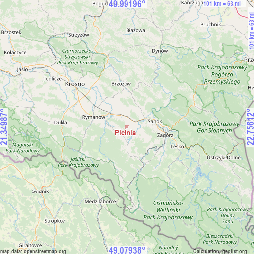
Pielnia GPS coordinates[2]
49° 32' 16.08" North, 22° 3' 10.764" East
| Map corner | latitude | longitude |
|---|---|---|
| Upper-left | 49.99196°, | 21.34987° |
| Center: | 49.5378°, | 22.05299° |
| Lower-right: | 49.07938°, | 22.75612° |
| Map W x H: | 101.5×101.5 km | = 63.1×63.1mi |
| max Lat: | 54.83135° ⇑97.8% North |
| Pielnia: | 49.5378° |
| min Lat: | ⇓2.2% South 49.21328° |
| min Long | Pielnia | max Long |
| 14.20249° | 22.05299° | 24.03723° |
| W 85.5%⇐ | ⇒14.5% E |
Elevation
Elevation of Pielnia is 336 m = 1102 ft, and this is 144.6 m = 474 ft above average elevation for this country.
| Max E: |
974 m = 3196 ft | 9.6% |
| Pielnia | 336 m 1102 ft | |
| Avg. | 191.4 m = 628 ft | |
Min E: |
-3 m = -10 ft | 90.4% |
See also: Poland elevation on elevation.city.
Geographical zone
Pielnia is located in North temperate zone (between Tropic of Cancer and the Arctic Circle). Distance of this North polar circle is 1893.1 km =1176.3 mi to North.| Distance of | km | miles | from Pielnia |
|---|---|---|---|
| North Pole | 4499 | 2795.5 | to North |
| Arctic Circle | 1893.1 | 1176.3 | to North |
| Tropic Cancer | 2902.2 | 1803.3 | to South |
| Equator | 5508.1 | 3422.6 | to South |


Nearby cities:
15 places around Pielnia: (largest is in red/bold)
• Besko
9.1 km =5.7 mi,  307°
307°
• Bukowsko
6.4 km =4 mi,  173°
173°
• Długie
4.6 km =2.9 mi,  351°
351°
• Grabownica Starzeńska
13.6 km =8.5 mi,  7°
7°
• Górki
11.8 km =7.3 mi,  356°
356°
• Głębokie
10.3 km =6.4 mi,  274°
274°
• Kostarowce
6.9 km =4.3 mi,  39°
39°
• Niebieszczany
8.4 km =5.2 mi,  117°
117°
• Nowosielce-Gniewosz
3.6 km =2.2 mi,  19°
19°
• Pakoszówka
10.2 km =6.3 mi, 21°
• Pisarowce
3.9 km =2.4 mi,  53°
53°
• Sanok
11.2 km =7 mi,  79°
79°
• Sieniawa
9.5 km =5.9 mi,  288°
288°
• Strachocina
8.2 km =5.1 mi, 18°
• Zarszyn
5.7 km =3.5 mi,  329°
329°
Sources, notices
• [Note1] Compared only with cities in Poland existing in our database
• [Src1] Map data: © OpenStreetMap contributors (CC-BY-SA)
• [Src2] Other city data from geonames.org with taken over terms of usage.
• [Src3] Geographical zone / Annual Mean Temperature by Robert A. Rohde @ Wikipedia
