Besko geodata
Besko (Subcarpathian) is a seat of a third-order administrative division; located in Poland in Europe/Warsaw (GMT+2) time zone. With population of 3,700 people, there are 871 cities with bigger population in this country. Compared to other cities in Poland, 96.7% of cities are located further ↑North; 84.2% of cities are located further ←West and 85.4% of cities have lower elevation than Besko. Note1


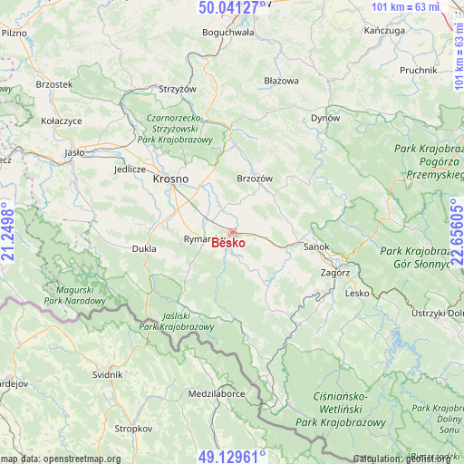
Besko GPS coordinates[2]
49° 35' 15.252" North, 21° 57' 10.512" East
| Map corner | latitude | longitude |
|---|---|---|
| Upper-left | 50.04127°, | 21.2498° |
| Center: | 49.58757°, | 21.95292° |
| Lower-right: | 49.12961°, | 22.65605° |
| Map W x H: | 101.4×101.4 km | = 63×63mi |
| max Lat: | 54.83135° ⇑96.7% North |
| Besko: | 49.58757° |
| min Lat: | ⇓3.3% South 49.21328° |
| min Long | Besko | max Long |
| 14.20249° | 21.95292° | 24.03723° |
| W 84.2%⇐ | ⇒15.8% E |
Elevation
Elevation of Besko is 292 m = 958 ft, and this is 100.6 m = 330 ft above average elevation for this country.
| Max E: |
974 m = 3196 ft | 14.6% |
| Besko | 292 m 958 ft | |
| Avg. | 191.4 m = 628 ft | |
Min E: |
-3 m = -10 ft | 85.4% |
See also: Poland elevation on elevation.city.
Geographical zone
Besko is located in North temperate zone (between Tropic of Cancer and the Arctic Circle). Distance of this North polar circle is 1887.6 km =1172.9 mi to North.| Distance of | km | miles | from Besko |
|---|---|---|---|
| North Pole | 4493.4 | 2792.1 | to North |
| Arctic Circle | 1887.6 | 1172.9 | to North |
| Tropic Cancer | 2907.7 | 1806.8 | to South |
| Equator | 5513.6 | 3426 | to South |


Nearby cities:
15 places around Besko: (largest is in red/bold)
• Długie
6.6 km =4.1 mi,  98°
98°
• Górki
9 km =5.6 mi,  46°
46°
• Głębokie
5.6 km =3.5 mi,  213°
213°
• Haczów
9.1 km =5.7 mi,  334°
334°
• Jasionów
8.1 km =5 mi,  12°
12°
• Kostarowce
11.6 km =7.2 mi,  90°
90°
• Nowosielce-Gniewosz
8.7 km =5.4 mi, 104°
• Pielnia
9.1 km =5.7 mi,  127°
127°
• Pisarowce
10.8 km =6.7 mi,  107°
107°
• Rymanów
6.2 km =3.9 mi,  258°
258°
• Sieniawa
3.1 km =1.9 mi,  215°
215°
• Strachocina
10 km =6.2 mi,  76°
76°
• Turze Pole
9.2 km =5.7 mi,  23°
23°
• Zarszyn
4.4 km =2.7 mi, 98°
• Zmiennica
9.9 km =6.2 mi, 5°
Sources, notices
• [Note1] Compared only with cities in Poland existing in our database
• [Src1] Map data: © OpenStreetMap contributors (CC-BY-SA)
• [Src2] Other city data from geonames.org with taken over terms of usage.
• [Src3] Geographical zone / Annual Mean Temperature by Robert A. Rohde @ Wikipedia
