Wilanów geodata
Wilanów (Mazovia) is a populated place; located in Poland in Europe/Warsaw (GMT+2) time zone. With population of 14,032 people, there are 352 cities with bigger population in this country. Compared to other cities in Poland, 69.2% of cities are located further ↓South; 74.3% of cities are located further ←West and 86.8% of cities have higher elevation than Wilanów. Note1


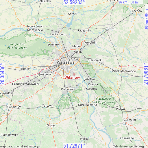
Wilanów GPS coordinates[2]
52° 9' 47.196" North, 21° 5' 14.928" East
| Map corner | latitude | longitude |
|---|---|---|
| Upper-left | 52.59233°, | 20.38436° |
| Center: | 52.16311°, | 21.08748° |
| Lower-right: | 51.72971°, | 21.79061° |
| Map W x H: | 95.9×95.9 km | = 59.6×59.6mi |
| max Lat: | 54.83135° ⇑30.8% North |
| Wilanów: | 52.16311° |
| min Lat: | ⇓69.2% South 49.21328° |
| min Long | Wilanów | max Long |
| 14.20249° | 21.08748° | 24.03723° |
| W 74.3%⇐ | ⇒25.7% E |
Elevation
Elevation of Wilanów is 85 m = 279 ft, and this is 106.4 m = 349 ft below average elevation for this country.
| Max E: |
974 m = 3196 ft | 86.8% |
| Avg. | 191.4 m = 628 ft | |
| Wilanów | 85 m = 279 ft | |
Min E: |
-3 m = -10 ft | 13.2% |
See also: Poland elevation on elevation.city.
Geographical zone
Wilanów is located in North temperate zone (between Tropic of Cancer and the Arctic Circle). Distance of this North polar circle is 1601.2 km =994.9 mi to North.| Distance of | km | miles | from Wilanów |
|---|---|---|---|
| North Pole | 4207.1 | 2614.2 | to North |
| Arctic Circle | 1601.2 | 994.9 | to North |
| Tropic Cancer | 3194.1 | 1984.7 | to South |
| Equator | 5800 | 3604 | to South |


Nearby cities:
15 places around Wilanów: (largest is in red/bold)
• Bielawa
6.7 km =4.2 mi,  153°
153°
• Chylice
9.6 km =6 mi,  190°
190°
• Chyliczki
8.7 km =5.4 mi, 187°
• Jaworowa
9.1 km =5.7 mi,  256°
256°
• Józefosław
7.5 km =4.7 mi,  201°
201°
• Kabaty
3.7 km =2.3 mi, 186°
• Konstancin-Jeziorna
8 km =5 mi,  165°
165°
• Mokotów
4.9 km =3 mi,  313°
313°
• Mysiadło
8.2 km =5.1 mi,  214°
214°
• Ochota
9.5 km =5.9 mi, 312°
• Praga Południe
9 km =5.6 mi,  359°
359°
• Ursynów
2.9 km =1.8 mi,  241°
241°
• Warsaw
9 km =5.6 mi,  325°
325°
• Wawer
7.2 km =4.5 mi,  58°
58°
• Śródmieście
8.8 km =5.5 mi, 326°
Sources, notices
• [Note1] Compared only with cities in Poland existing in our database
• [Src1] Map data: © OpenStreetMap contributors (CC-BY-SA)
• [Src2] Other city data from geonames.org with taken over terms of usage.
• [Src3] Geographical zone / Annual Mean Temperature by Robert A. Rohde @ Wikipedia
