Ząbki geodata
Ząbki (Mazovia) is a seat of a third-order administrative division; located in Poland in Europe/Warsaw (GMT+2) time zone. With population of 23,473 people, there are 206 cities with bigger population in this country. Compared to other cities in Poland, 72.3% of cities are located further ↓South; 74.6% of cities are located further ←West and 87.5% of cities have higher elevation than Ząbki. Note1


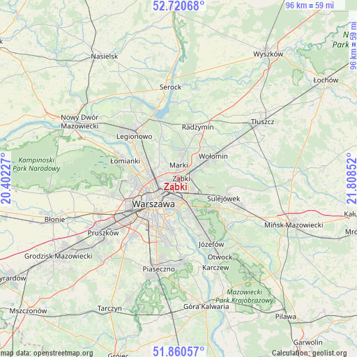
Ząbki GPS coordinates[2]
52° 17' 33.756" North, 21° 6' 19.404" East
| Map corner | latitude | longitude |
|---|---|---|
| Upper-left | 52.72068°, | 20.40227° |
| Center: | 52.29271°, | 21.10539° |
| Lower-right: | 51.86057°, | 21.80852° |
| Map W x H: | 95.6×95.6 km | = 59.4×59.4mi |
| max Lat: | 54.83135° ⇑27.7% North |
| Ząbki: | 52.29271° |
| min Lat: | ⇓72.3% South 49.21328° |
| min Long | Ząbki | max Long |
| 14.20249° | 21.10539° | 24.03723° |
| W 74.6%⇐ | ⇒25.4% E |
Elevation
Elevation of Ząbki is 83 m = 272 ft, and this is 108.4 m = 356 ft below average elevation for this country.
| Max E: |
974 m = 3196 ft | 87.5% |
| Avg. | 191.4 m = 628 ft | |
| Ząbki | 83 m = 272 ft | |
Min E: |
-3 m = -10 ft | 12.5% |
See also: Poland elevation on elevation.city.
Geographical zone
Ząbki is located in North temperate zone (between Tropic of Cancer and the Arctic Circle). Distance of this North polar circle is 1586.8 km =986 mi to North.| Distance of | km | miles | from Ząbki |
|---|---|---|---|
| North Pole | 4192.7 | 2605.2 | to North |
| Arctic Circle | 1586.8 | 986 | to North |
| Tropic Cancer | 3208.5 | 1993.7 | to South |
| Equator | 5814.4 | 3612.9 | to South |


Nearby cities:
15 places around Ząbki: (largest is in red/bold)
• Białołeka
9.6 km =6 mi,  289°
289°
• Kobyłka
8.1 km =5 mi,  49°
49°
• Marki
3.1 km =1.9 mi,  359°
359°
• Praga Południe
5.6 km =3.5 mi,  194°
194°
• Praga Północ
6.4 km =4 mi,  228°
228°
• Rembertów
5.3 km =3.3 mi,  132°
132°
• Stanisławów Pierwszy
9.8 km =6.1 mi,  338°
338°
• Słupno
10.7 km =6.6 mi,  18°
18°
• Targówek
3.9 km =2.4 mi,  268°
268°
• Warsaw
9.5 km =5.9 mi,  222°
222°
• Wesoła
9.1 km =5.7 mi,  117°
117°
• Wola
9.9 km =6.2 mi, 233°
• Zielonka
3.9 km =2.4 mi,  71°
71°
• Śródmieście
9.3 km =5.8 mi, 220°
• Żoliborz
8.5 km =5.3 mi,  251°
251°
Sources, notices
• [Note1] Compared only with cities in Poland existing in our database
• [Src1] Map data: © OpenStreetMap contributors (CC-BY-SA)
• [Src2] Other city data from geonames.org with taken over terms of usage.
• [Src3] Geographical zone / Annual Mean Temperature by Robert A. Rohde @ Wikipedia
