Sosnowica geodata
Sosnowica (Lublin) is a seat of a third-order administrative division; located in Poland in Europe/Warsaw (GMT+2) time zone. With population of 678 people, there are 3117 cities with bigger population in this country. Compared to other cities in Poland, 56.7% of cities are located further ↓South; 96.7% of cities are located further ←West and 52.5% of cities have higher elevation than Sosnowica. Note1


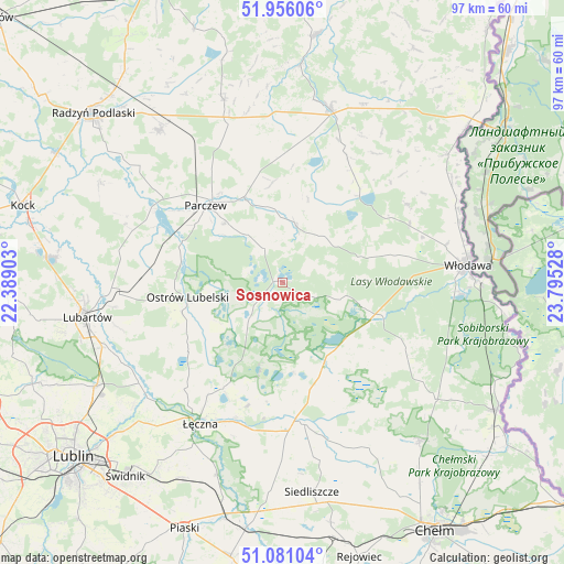
Sosnowica GPS coordinates[2]
51° 31' 14.34" North, 23° 5' 31.74" East
| Map corner | latitude | longitude |
|---|---|---|
| Upper-left | 51.95606°, | 22.38903° |
| Center: | 51.52065°, | 23.09215° |
| Lower-right: | 51.08104°, | 23.79528° |
| Map W x H: | 97.3×97.3 km | = 60.5×60.5mi |
| max Lat: | 54.83135° ⇑43.3% North |
| Sosnowica: | 51.52065° |
| min Lat: | ⇓56.7% South 49.21328° |
| min Long | Sosnowica | max Long |
| 14.20249° | 23.09215° | 24.03723° |
| W 96.7%⇐ | ⇒3.3% E |
Elevation
Elevation of Sosnowica is 165 m = 541 ft, and this is 26.4 m = 87 ft below average elevation for this country.
| Max E: |
974 m = 3196 ft | 52.5% |
| Avg. | 191.4 m = 628 ft | |
| Sosnowica | 165 m = 541 ft | |
Min E: |
-3 m = -10 ft | 47.5% |
See also: Poland elevation on elevation.city.
Geographical zone
Sosnowica is located in North temperate zone (between Tropic of Cancer and the Arctic Circle). Distance of this North polar circle is 1672.6 km =1039.3 mi to North.| Distance of | km | miles | from Sosnowica |
|---|---|---|---|
| North Pole | 4278.5 | 2658.5 | to North |
| Arctic Circle | 1672.6 | 1039.3 | to North |
| Tropic Cancer | 3122.6 | 1940.3 | to South |
| Equator | 5728.6 | 3559.6 | to South |


Nearby cities:
15 places around Sosnowica: (largest is in red/bold)
• Brzeźnica Bychawska
23.6 km =14.7 mi,  271°
271°
• Cyców
24.8 km =15.4 mi,  172°
172°
• Dębowa Kłoda
10.1 km =6.3 mi,  324°
324°
• Hańsk
24.4 km =15.2 mi,  119°
119°
• Jabłoń
22.7 km =14.1 mi,  359°
359°
• Kostry
23 km =14.3 mi,  327°
327°
• Krasne
15 km =9.3 mi,  218°
218°
• Ludwin
23.3 km =14.5 mi,  213°
213°
• Milanów
24.7 km =15.3 mi, 325°
• Ostrów Lubelski
16.8 km =10.4 mi,  259°
259°
• Parczew
18.8 km =11.7 mi, 315°
• Podedwórze
20 km =12.4 mi,  21°
21°
• Urszulin
15.8 km =9.8 mi,  153°
153°
• Uścimów Nowy
13.4 km =8.3 mi,  240°
240°
• Uścimów Stary
11.1 km =6.9 mi, 239°
Sources, notices
• [Note1] Compared only with cities in Poland existing in our database
• [Src1] Map data: © OpenStreetMap contributors (CC-BY-SA)
• [Src2] Other city data from geonames.org with taken over terms of usage.
• [Src3] Geographical zone / Annual Mean Temperature by Robert A. Rohde @ Wikipedia
