Cyców geodata
Cyców (Lublin) is a seat of a third-order administrative division; located in Poland in Europe/Warsaw (GMT+2) time zone. With population of 1,200 people, there are 2164 cities with bigger population in this country. Compared to other cities in Poland, 53.1% of cities are located further ↓South; 97% of cities are located further ←West and 50.2% of cities have higher elevation than Cyców. Note1


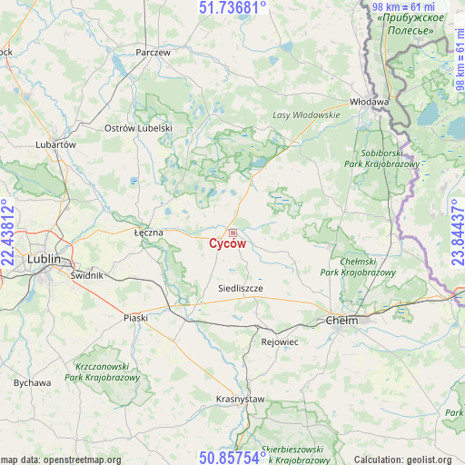
Cyców GPS coordinates[2]
51° 17' 57.408" North, 23° 8' 28.464" East
| Map corner | latitude | longitude |
|---|---|---|
| Upper-left | 51.73681°, | 22.43812° |
| Center: | 51.29928°, | 23.14124° |
| Lower-right: | 50.85754°, | 23.84437° |
| Map W x H: | 97.8×97.8 km | = 60.8×60.8mi |
| max Lat: | 54.83135° ⇑46.9% North |
| Cyców: | 51.29928° |
| min Lat: | ⇓53.1% South 49.21328° |
| min Long | Cyców | max Long |
| 14.20249° | 23.14124° | 24.03723° |
| W 97%⇐ | ⇒3% E |
Elevation
Elevation of Cyców is 171 m = 561 ft, and this is 20.4 m = 67 ft below average elevation for this country.
| Max E: |
974 m = 3196 ft | 50.2% |
| Avg. | 191.4 m = 628 ft | |
| Cyców | 171 m = 561 ft | |
Min E: |
-3 m = -10 ft | 49.8% |
See also: Poland elevation on elevation.city.
Geographical zone
Cyców is located in North temperate zone (between Tropic of Cancer and the Arctic Circle). Distance of this North polar circle is 1697.2 km =1054.6 mi to North.| Distance of | km | miles | from Cyców |
|---|---|---|---|
| North Pole | 4303.1 | 2673.8 | to North |
| Arctic Circle | 1697.2 | 1054.6 | to North |
| Tropic Cancer | 3098 | 1925 | to South |
| Equator | 5703.9 | 3544.2 | to South |


Nearby cities:
15 places around Cyców: (largest is in red/bold)
• Hańsk
21.9 km =13.6 mi,  54°
54°
• Krasne
18.2 km =11.3 mi,  315°
315°
• Krasne
18.8 km =11.7 mi,  169°
169°
• Ludwin
17.2 km =10.7 mi,  287°
287°
• Milejów
16.8 km =10.4 mi,  243°
243°
• Pawłów
17.7 km =11 mi,  163°
163°
• Puchaczów
11.7 km =7.3 mi,  276°
276°
• Rejowiec Fabryczny
21.9 km =13.6 mi, 160°
• Sawin
20.5 km =12.7 mi,  97°
97°
• Siedliszcze
11.7 km =7.3 mi, 172°
• Trawniki
20.7 km =12.9 mi,  208°
208°
• Urszulin
11.2 km =7 mi,  19°
19°
• Uścimów Nowy
23.6 km =14.7 mi, 320°
• Uścimów Stary
22.9 km =14.2 mi,  325°
325°
• Łęczna
18.1 km =11.2 mi,  270°
270°
Sources, notices
• [Note1] Compared only with cities in Poland existing in our database
• [Src1] Map data: © OpenStreetMap contributors (CC-BY-SA)
• [Src2] Other city data from geonames.org with taken over terms of usage.
• [Src3] Geographical zone / Annual Mean Temperature by Robert A. Rohde @ Wikipedia
