Ostrów Lubelski geodata
Ostrów Lubelski (Lublin) is a seat of a third-order administrative division; located in Poland in Europe/Warsaw (GMT+2) time zone. With population of 2,206 people, there are 1358 cities with bigger population in this country. Compared to other cities in Poland, 56.2% of cities are located further ↓South; 94.9% of cities are located further ←West and 58.4% of cities have higher elevation than Ostrów Lubelski. Note1


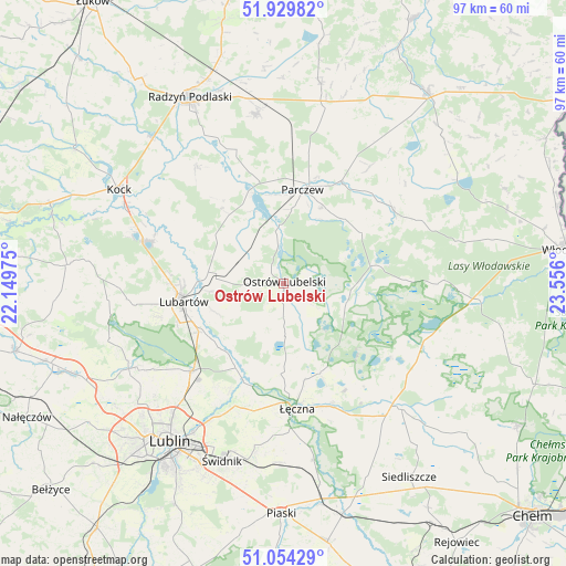
Ostrów Lubelski GPS coordinates[2]
51° 29' 38.976" North, 22° 51' 10.332" East
| Map corner | latitude | longitude |
|---|---|---|
| Upper-left | 51.92982°, | 22.14975° |
| Center: | 51.49416°, | 22.85287° |
| Lower-right: | 51.05429°, | 23.556° |
| Map W x H: | 97.3×97.3 km | = 60.5×60.5mi |
| max Lat: | 54.83135° ⇑43.8% North |
| Ostrów Lubelski: | 51.49416° |
| min Lat: | ⇓56.2% South 49.21328° |
| min Long | Ostrów Lubelsk | max Long |
| 14.20249° | 22.85287° | 24.03723° |
| W 94.9%⇐ | ⇒5.1% E |
Elevation
Elevation of Ostrów Lubelski is 150 m = 492 ft, and this is 41.4 m = 136 ft below average elevation for this country.
| Max E: |
974 m = 3196 ft | 58.4% |
| Avg. | 191.4 m = 628 ft | |
| Ostrów Lubelski | 150 m = 492 ft | |
Min E: |
-3 m = -10 ft | 41.6% |
See also: Poland elevation on elevation.city.
Geographical zone
Ostrów Lubelski is located in North temperate zone (between Tropic of Cancer and the Arctic Circle). Distance of this North polar circle is 1675.6 km =1041.2 mi to North.| Distance of | km | miles | from Ostrów Lubelski |
|---|---|---|---|
| North Pole | 4281.4 | 2660.3 | to North |
| Arctic Circle | 1675.6 | 1041.2 | to North |
| Tropic Cancer | 3119.7 | 1938.5 | to South |
| Equator | 5725.6 | 3557.7 | to South |


Nearby cities:
15 places around Ostrów Lubelski: (largest is in red/bold)
• Brzeźnica Bychawska
8 km =5 mi,  297°
297°
• Dębowa Kłoda
15.4 km =9.6 mi,  43°
43°
• Krasne
11.3 km =7 mi,  140°
140°
• Lubartów
17.3 km =10.7 mi,  257°
257°
• Ludwin
16.9 km =10.5 mi,  167°
167°
• Niedźwiada
12.5 km =7.8 mi, 296°
• Parczew
16.6 km =10.3 mi,  11°
11°
• Pałecznica
12.5 km =7.8 mi, 264°
• Serniki
14.9 km =9.3 mi,  244°
244°
• Siemień
16 km =9.9 mi,  339°
339°
• Sosnowica
16.8 km =10.4 mi,  79°
79°
• Spiczyn
18.3 km =11.4 mi,  202°
202°
• Uścimów Nowy
6 km =3.7 mi,  126°
126°
• Uścimów Stary
7.6 km =4.7 mi,  111°
111°
• Wola Sernicka
12.7 km =7.9 mi,  247°
247°
Sources, notices
• [Note1] Compared only with cities in Poland existing in our database
• [Src1] Map data: © OpenStreetMap contributors (CC-BY-SA)
• [Src2] Other city data from geonames.org with taken over terms of usage.
• [Src3] Geographical zone / Annual Mean Temperature by Robert A. Rohde @ Wikipedia
