Hańsk geodata
Hańsk (Lublin) is a populated place; located in Poland in Europe/Warsaw (GMT+2) time zone. With population of 1,017 people, there are 2435 cities with bigger population in this country. Compared to other cities in Poland, 55% of cities are located further ↓South; 98.4% of cities are located further ←West and 51.3% of cities have higher elevation than Hańsk. Note1


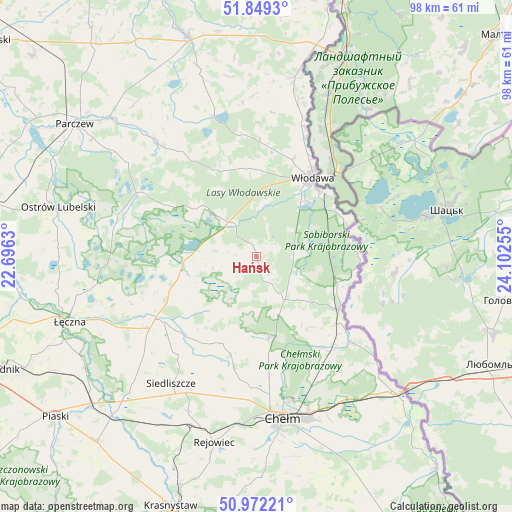
Hańsk GPS coordinates[2]
51° 24' 46.296" North, 23° 23' 57.912" East
| Map corner | latitude | longitude |
|---|---|---|
| Upper-left | 51.8493°, | 22.6963° |
| Center: | 51.41286°, | 23.39942° |
| Lower-right: | 50.97221°, | 24.10255° |
| Map W x H: | 97.5×97.5 km | = 60.6×60.6mi |
| max Lat: | 54.83135° ⇑45% North |
| Hańsk: | 51.41286° |
| min Lat: | ⇓55% South 49.21328° |
| min Long | Hańsk | max Long |
| 14.20249° | 23.39942° | 24.03723° |
| W 98.4%⇐ | ⇒1.6% E |
Elevation
Elevation of Hańsk is 169 m = 554 ft, and this is 22.4 m = 73 ft below average elevation for this country.
| Max E: |
974 m = 3196 ft | 51.3% |
| Avg. | 191.4 m = 628 ft | |
| Hańsk | 169 m = 554 ft | |
Min E: |
-3 m = -10 ft | 48.7% |
See also: Poland elevation on elevation.city.
Geographical zone
Hańsk is located in North temperate zone (between Tropic of Cancer and the Arctic Circle). Distance of this North polar circle is 1684.6 km =1046.8 mi to North.| Distance of | km | miles | from Hańsk |
|---|---|---|---|
| North Pole | 4290.5 | 2666 | to North |
| Arctic Circle | 1684.6 | 1046.8 | to North |
| Tropic Cancer | 3110.7 | 1932.9 | to South |
| Equator | 5716.6 | 3552.1 | to South |


Nearby cities:
15 places around Hańsk: (largest is in red/bold)
• Chełm
30.4 km =18.9 mi,  170°
170°
• Cyców
21.9 km =13.6 mi,  234°
234°
• Krasne
30.7 km =19.1 mi,  270°
270°
• Pawłów
32.3 km =20.1 mi,  203°
203°
• Puchaczów
31.7 km =19.7 mi,  248°
248°
• Ruda-Huta
23.8 km =14.8 mi,  145°
145°
• Sawin
15.6 km =9.7 mi, 171°
• Siedliszcze
22 km =13.7 mi,  131°
131°
• Siedliszcze
29.3 km =18.2 mi,  214°
214°
• Sosnowica
24.4 km =15.2 mi,  299°
299°
• Urszulin
14.3 km =8.9 mi,  261°
261°
• Uścimów Stary
31.4 km =19.5 mi,  281°
281°
• Wola Uhruska
18.7 km =11.6 mi,  122°
122°
• Włodawa
18.5 km =11.5 mi,  34°
34°
• Świerże
31.9 km =19.8 mi, 133°
Sources, notices
• [Note1] Compared only with cities in Poland existing in our database
• [Src1] Map data: © OpenStreetMap contributors (CC-BY-SA)
• [Src2] Other city data from geonames.org with taken over terms of usage.
• [Src3] Geographical zone / Annual Mean Temperature by Robert A. Rohde @ Wikipedia
