Rokitno geodata
Rokitno (Lublin) is a seat of a third-order administrative division; located in Poland in Europe/Warsaw (GMT+2) time zone. With population of 747 people, there are 2976 cities with bigger population in this country. Compared to other cities in Poland, 68.3% of cities are located further ↓South; 97.8% of cities are located further ←West and 58.4% of cities have higher elevation than Rokitno. Note1


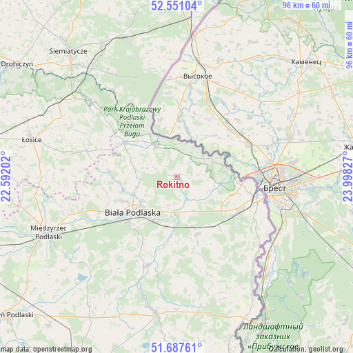
Rokitno GPS coordinates[2]
52° 7' 17.112" North, 23° 17' 42.504" East
| Map corner | latitude | longitude |
|---|---|---|
| Upper-left | 52.55104°, | 22.59202° |
| Center: | 52.12142°, | 23.29514° |
| Lower-right: | 51.68761°, | 23.99827° |
| Map W x H: | 96×96 km | = 59.7×59.7mi |
| max Lat: | 54.83135° ⇑31.7% North |
| Rokitno: | 52.12142° |
| min Lat: | ⇓68.3% South 49.21328° |
| min Long | Rokitno | max Long |
| 14.20249° | 23.29514° | 24.03723° |
| W 97.8%⇐ | ⇒2.2% E |
Elevation
Elevation of Rokitno is 150 m = 492 ft, and this is 41.4 m = 136 ft below average elevation for this country.
| Max E: |
974 m = 3196 ft | 58.4% |
| Avg. | 191.4 m = 628 ft | |
| Rokitno | 150 m = 492 ft | |
Min E: |
-3 m = -10 ft | 41.6% |
See also: Poland elevation on elevation.city.
Geographical zone
Rokitno is located in North temperate zone (between Tropic of Cancer and the Arctic Circle). Distance of this North polar circle is 1605.8 km =997.8 mi to North.| Distance of | km | miles | from Rokitno |
|---|---|---|---|
| North Pole | 4211.7 | 2617 | to North |
| Arctic Circle | 1605.8 | 997.8 | to North |
| Tropic Cancer | 3189.4 | 1981.8 | to South |
| Equator | 5795.4 | 3601.1 | to South |


Nearby cities:
15 places around Rokitno: (largest is in red/bold)
• Biała Podlaska
15.7 km =9.8 mi,  230°
230°
• Huszlew
31.5 km =19.6 mi,  273°
273°
• Janów Podlaski
9.9 km =6.2 mi,  324°
324°
• Kodeń
31.4 km =19.5 mi,  137°
137°
• Konstantynów
17.2 km =10.7 mi,  303°
303°
• Kostomłoty
29.5 km =18.3 mi,  123°
123°
• Leśna Podlaska
18.3 km =11.4 mi, 274°
• Mielnik
29 km =18 mi, 323°
• Piszczac
16.6 km =10.3 mi,  160°
160°
• Rossosz
31.2 km =19.4 mi,  200°
200°
• Stara Kornica
25.3 km =15.7 mi,  285°
285°
• Terespol
22.5 km =14 mi,  103°
103°
• Tuczna
28.3 km =17.6 mi, 161°
• Zalesie
10.4 km =6.5 mi,  153°
153°
• Łomazy
25.5 km =15.8 mi, 198°
Sources, notices
• [Note1] Compared only with cities in Poland existing in our database
• [Src1] Map data: © OpenStreetMap contributors (CC-BY-SA)
• [Src2] Other city data from geonames.org with taken over terms of usage.
• [Src3] Geographical zone / Annual Mean Temperature by Robert A. Rohde @ Wikipedia
