Mielnik geodata
Mielnik (Podlasie) is a populated place; located in Poland in Europe/Warsaw (GMT+2) time zone. With population of 980 people, there are 2532 cities with bigger population in this country. Compared to other cities in Poland, 73.3% of cities are located further ↓South; 96.5% of cities are located further ←West and 62.4% of cities have higher elevation than Mielnik. Note1


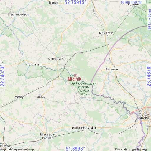
Mielnik GPS coordinates[2]
52° 19' 53.616" North, 23° 2' 37.14" East
| Map corner | latitude | longitude |
|---|---|---|
| Upper-left | 52.75915°, | 22.34053° |
| Center: | 52.33156°, | 23.04365° |
| Lower-right: | 51.8998°, | 23.74678° |
| Map W x H: | 95.6×95.5 km | = 59.4×59.3mi |
| max Lat: | 54.83135° ⇑26.7% North |
| Mielnik: | 52.33156° |
| min Lat: | ⇓73.3% South 49.21328° |
| min Long | Mielnik | max Long |
| 14.20249° | 23.04365° | 24.03723° |
| W 96.5%⇐ | ⇒3.5% E |
Elevation
Elevation of Mielnik is 141 m = 463 ft, and this is 50.4 m = 165 ft below average elevation for this country.
| Max E: |
974 m = 3196 ft | 62.4% |
| Avg. | 191.4 m = 628 ft | |
| Mielnik | 141 m = 463 ft | |
Min E: |
-3 m = -10 ft | 37.6% |
See also: Poland elevation on elevation.city.
Geographical zone
Mielnik is located in North temperate zone (between Tropic of Cancer and the Arctic Circle). Distance of this North polar circle is 1582.5 km =983.3 mi to North.| Distance of | km | miles | from Mielnik |
|---|---|---|---|
| North Pole | 4188.3 | 2602.5 | to North |
| Arctic Circle | 1582.5 | 983.3 | to North |
| Tropic Cancer | 3212.8 | 1996.3 | to South |
| Equator | 5818.7 | 3615.6 | to South |


Nearby cities:
15 places around Mielnik: (largest is in red/bold)
• Czeremcha
29.2 km =18.1 mi,  45°
45°
• Drohiczyn
27.2 km =16.9 mi,  286°
286°
• Dziadkowice
27.2 km =16.9 mi,  341°
341°
• Huszlew
25.8 km =16 mi,  213°
213°
• Janów Podlaski
19.1 km =11.9 mi,  143°
143°
• Konstantynów
14.1 km =8.8 mi,  168°
168°
• Leśna Podlaska
22.1 km =13.7 mi,  182°
182°
• Milejczyce
21.8 km =13.5 mi,  15°
15°
• Nurzec-Stacja
14.8 km =9.2 mi,  11°
11°
• Platerów
15.5 km =9.6 mi,  258°
258°
• Rokitno
29 km =18 mi, 143°
• Sarnaki
10.6 km =6.6 mi, 259°
• Siemiatycze
16.3 km =10.1 mi,  310°
310°
• Stara Kornica
18.1 km =11.2 mi,  203°
203°
• Łosice
25.9 km =16.1 mi,  238°
238°
Sources, notices
• [Note1] Compared only with cities in Poland existing in our database
• [Src1] Map data: © OpenStreetMap contributors (CC-BY-SA)
• [Src2] Other city data from geonames.org with taken over terms of usage.
• [Src3] Geographical zone / Annual Mean Temperature by Robert A. Rohde @ Wikipedia
