Biała Podlaska geodata
Biała Podlaska (Lublin) is a seat of a second-order administrative division; located in Poland in Europe/Warsaw (GMT+2) time zone. With population of 57,541 people, there are 91 cities with bigger population in this country. Compared to other cities in Poland, 66.2% of cities are located further ↓South; 96.8% of cities are located further ←West and 62.1% of cities have higher elevation than Biała Podlaska. Note1


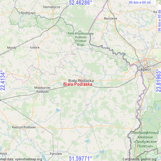
Biała Podlaska GPS coordinates[2]
52° 1' 56.568" North, 23° 6' 59.472" East
| Map corner | latitude | longitude |
|---|---|---|
| Upper-left | 52.46286°, | 22.4134° |
| Center: | 52.03238°, | 23.11652° |
| Lower-right: | 51.59771°, | 23.81965° |
| Map W x H: | 96.2×96.2 km | = 59.8×59.8mi |
| max Lat: | 54.83135° ⇑33.8% North |
| Biała Podlaska: | 52.03238° |
| min Lat: | ⇓66.2% South 49.21328° |
| min Long | Biała Podlaska | max Long |
| 14.20249° | 23.11652° | 24.03723° |
| W 96.8%⇐ | ⇒3.2% E |
Elevation
Elevation of Biała Podlaska is 142 m = 466 ft, and this is 49.4 m = 162 ft below average elevation for this country.
| Max E: |
974 m = 3196 ft | 62.1% |
| Avg. | 191.4 m = 628 ft | |
| Biała Podlaska | 142 m = 466 ft | |
Min E: |
-3 m = -10 ft | 37.9% |
See also: Biała Podlaska elevation on elevation.city.
Geographical zone
Biała Podlaska is located in North temperate zone (between Tropic of Cancer and the Arctic Circle). Distance of this North polar circle is 1615.7 km =1003.9 mi to North.| Distance of | km | miles | from Biała Podlaska |
|---|---|---|---|
| North Pole | 4221.6 | 2623.2 | to North |
| Arctic Circle | 1615.7 | 1003.9 | to North |
| Tropic Cancer | 3179.5 | 1975.6 | to South |
| Equator | 5785.5 | 3594.9 | to South |


Nearby cities:
15 places around Biała Podlaska: (largest is in red/bold)
• Drelów
21.4 km =13.3 mi,  231°
231°
• Huszlew
22.6 km =14 mi,  301°
301°
• Janów Podlaski
19.1 km =11.9 mi,  19°
19°
• Konstantynów
19.6 km =12.2 mi,  353°
353°
• Leśna Podlaska
12.7 km =7.9 mi,  331°
331°
• Międzyrzec Podlaski
23.4 km =14.5 mi,  257°
257°
• Piszczac
18.7 km =11.6 mi,  107°
107°
• Rokitno
15.7 km =9.8 mi,  50°
50°
• Rossosz
19.4 km =12.1 mi,  175°
175°
• Rzeczyca
26.3 km =16.3 mi,  252°
252°
• Stara Kornica
20.6 km =12.8 mi,  323°
323°
• Tuczna
27.1 km =16.8 mi,  128°
128°
• Wisznice
27.8 km =17.3 mi,  166°
166°
• Zalesie
16.9 km =10.5 mi,  88°
88°
• Łomazy
14.8 km =9.2 mi,  163°
163°
Sources, notices
• [Note1] Compared only with cities in Poland existing in our database
• [Src1] Map data: © OpenStreetMap contributors (CC-BY-SA)
• [Src2] Other city data from geonames.org with taken over terms of usage.
• [Src3] Geographical zone / Annual Mean Temperature by Robert A. Rohde @ Wikipedia
