Konstantynów geodata
Konstantynów (Lublin) is a populated place; located in Poland in Europe/Warsaw (GMT+2) time zone. With population of 1,437 people, there are 1921 cities with bigger population in this country. Compared to other cities in Poland, 70.3% of cities are located further ↓South; 96.6% of cities are located further ←West and 57.1% of cities have higher elevation than Konstantynów. Note1


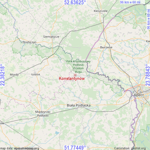
Konstantynów GPS coordinates[2]
52° 12' 26.856" North, 23° 5' 7.08" East
| Map corner | latitude | longitude |
|---|---|---|
| Upper-left | 52.63625°, | 22.38218° |
| Center: | 52.20746°, | 23.0853° |
| Lower-right: | 51.77449°, | 23.78843° |
| Map W x H: | 95.8×95.8 km | = 59.5×59.5mi |
| max Lat: | 54.83135° ⇑29.7% North |
| Konstantynów: | 52.20746° |
| min Lat: | ⇓70.3% South 49.21328° |
| min Long | Konstantynów | max Long |
| 14.20249° | 23.0853° | 24.03723° |
| W 96.6%⇐ | ⇒3.4% E |
Elevation
Elevation of Konstantynów is 153 m = 502 ft, and this is 38.4 m = 126 ft below average elevation for this country.
| Max E: |
974 m = 3196 ft | 57.1% |
| Avg. | 191.4 m = 628 ft | |
| Konstantynów | 153 m = 502 ft | |
Min E: |
-3 m = -10 ft | 42.9% |
See also: Poland elevation on elevation.city.
Geographical zone
Konstantynów is located in North temperate zone (between Tropic of Cancer and the Arctic Circle). Distance of this North polar circle is 1596.2 km =991.8 mi to North.| Distance of | km | miles | from Konstantynów |
|---|---|---|---|
| North Pole | 4202.1 | 2611.1 | to North |
| Arctic Circle | 1596.2 | 991.8 | to North |
| Tropic Cancer | 3199 | 1987.8 | to South |
| Equator | 5804.9 | 3607 | to South |


Nearby cities:
15 places around Konstantynów: (largest is in red/bold)
• Biała Podlaska
19.6 km =12.2 mi,  173°
173°
• Huszlew
18.8 km =11.7 mi,  245°
245°
• Janów Podlaski
8.8 km =5.5 mi,  99°
99°
• Leśna Podlaska
9.1 km =5.7 mi,  205°
205°
• Mielnik
14.1 km =8.8 mi,  348°
348°
• Międzyrzec Podlaski
32.1 km =19.9 mi,  220°
220°
• Nurzec-Stacja
28.4 km =17.6 mi,  0°
0°
• Piszczac
32.1 km =19.9 mi,  141°
141°
• Platerów
21 km =13 mi,  300°
300°
• Rokitno
17.2 km =10.7 mi,  123°
123°
• Sarnaki
17.9 km =11.1 mi,  312°
312°
• Siemiatycze
28.8 km =17.9 mi,  328°
328°
• Stara Kornica
10.5 km =6.5 mi, 254°
• Zalesie
26.8 km =16.7 mi,  134°
134°
• Łosice
25 km =15.5 mi,  270°
270°
Sources, notices
• [Note1] Compared only with cities in Poland existing in our database
• [Src1] Map data: © OpenStreetMap contributors (CC-BY-SA)
• [Src2] Other city data from geonames.org with taken over terms of usage.
• [Src3] Geographical zone / Annual Mean Temperature by Robert A. Rohde @ Wikipedia
