Ostrów geodata
Ostrów (Subcarpathian) is a populated place; located in Poland in Europe/Warsaw (GMT+2) time zone. With population of 1,800 people, there are 1605 cities with bigger population in this country. Compared to other cities in Poland, 84.5% of cities are located further ↑North; 94.5% of cities are located further ←West and 55.6% of cities have lower elevation than Ostrów. Note1


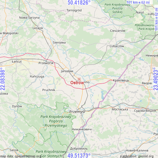
Ostrów GPS coordinates[2]
49° 58' 5.232" North, 22° 47' 13.56" East
| Map corner | latitude | longitude |
|---|---|---|
| Upper-left | 50.41826°, | 22.08398° |
| Center: | 49.96812°, | 22.7871° |
| Lower-right: | 49.51373°, | 23.49023° |
| Map W x H: | 100.6×100.6 km | = 62.5×62.5mi |
| max Lat: | 54.83135° ⇑84.5% North |
| Ostrów: | 49.96812° |
| min Lat: | ⇓15.5% South 49.21328° |
| min Long | Ostrów | max Long |
| 14.20249° | 22.7871° | 24.03723° |
| W 94.5%⇐ | ⇒5.5% E |
Elevation
Elevation of Ostrów is 187 m = 614 ft, and this is 4.4 m = 14 ft below average elevation for this country.
| Max E: |
974 m = 3196 ft | 44.4% |
| Avg. | 191.4 m = 628 ft | |
| Ostrów | 187 m = 614 ft | |
Min E: |
-3 m = -10 ft | 55.6% |
See also: Poland elevation on elevation.city.
Geographical zone
Ostrów is located in North temperate zone (between Tropic of Cancer and the Arctic Circle). Distance of this North polar circle is 1845.2 km =1146.6 mi to North.| Distance of | km | miles | from Ostrów |
|---|---|---|---|
| North Pole | 4451.1 | 2765.8 | to North |
| Arctic Circle | 1845.2 | 1146.6 | to North |
| Tropic Cancer | 2950 | 1833 | to South |
| Equator | 5555.9 | 3452.3 | to South |


Nearby cities:
15 places around Ostrów: (largest is in red/bold)
• Chłopice
8.3 km =5.2 mi,  254°
254°
• Cieszacin Wielki
14.1 km =8.8 mi,  281°
281°
• Jankowice
10 km =6.2 mi,  266°
266°
• Jarosław
9.5 km =5.9 mi,  304°
304°
• Laszki
9.9 km =6.2 mi,  54°
54°
• Małkowice
12.7 km =7.9 mi,  166°
166°
• Orły
10.9 km =6.8 mi, 173°
• Pawłosiów
10.4 km =6.5 mi,  286°
286°
• Radymno
3.5 km =2.2 mi,  131°
131°
• Rokietnica
12.9 km =8 mi,  233°
233°
• Rożwienica
13.9 km =8.6 mi,  262°
262°
• Sośnica
9.8 km =6.1 mi,  140°
140°
• Stubno
14.4 km =8.9 mi,  122°
122°
• Wierzbna
15.1 km =9.4 mi, 298°
• Wiązownica
13.8 km =8.6 mi,  335°
335°
Sources, notices
• [Note1] Compared only with cities in Poland existing in our database
• [Src1] Map data: © OpenStreetMap contributors (CC-BY-SA)
• [Src2] Other city data from geonames.org with taken over terms of usage.
• [Src3] Geographical zone / Annual Mean Temperature by Robert A. Rohde @ Wikipedia
