Pawłosiów geodata
Pawłosiów (Subcarpathian) is a populated place; located in Poland in Europe/Warsaw (GMT+2) time zone. With population of 1,800 people, there are 1605 cities with bigger population in this country. Compared to other cities in Poland, 82.6% of cities are located further ↑North; 93.2% of cities are located further ←West and 62.8% of cities have lower elevation than Pawłosiów. Note1


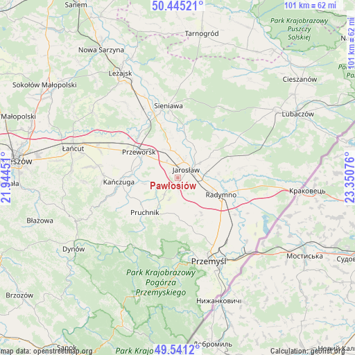
Pawłosiów GPS coordinates[2]
49° 59' 43.188" North, 22° 38' 51.468" East
| Map corner | latitude | longitude |
|---|---|---|
| Upper-left | 50.44521°, | 21.94451° |
| Center: | 49.99533°, | 22.64763° |
| Lower-right: | 49.5412°, | 23.35076° |
| Map W x H: | 100.5×100.5 km | = 62.4×62.4mi |
| max Lat: | 54.83135° ⇑82.6% North |
| Pawłosiów: | 49.99533° |
| min Lat: | ⇓17.4% South 49.21328° |
| min Long | Pawłosiów | max Long |
| 14.20249° | 22.64763° | 24.03723° |
| W 93.2%⇐ | ⇒6.8% E |
Elevation
Elevation of Pawłosiów is 208 m = 682 ft, and this is 16.6 m = 54 ft above average elevation for this country.
| Max E: |
974 m = 3196 ft | 37.2% |
| Pawłosiów | 208 m 682 ft | |
| Avg. | 191.4 m = 628 ft | |
Min E: |
-3 m = -10 ft | 62.8% |
See also: Poland elevation on elevation.city.
Geographical zone
Pawłosiów is located in North temperate zone (between Tropic of Cancer and the Arctic Circle). Distance of this North polar circle is 1842.2 km =1144.7 mi to North.| Distance of | km | miles | from Pawłosiów |
|---|---|---|---|
| North Pole | 4448.1 | 2763.9 | to North |
| Arctic Circle | 1842.2 | 1144.7 | to North |
| Tropic Cancer | 2953 | 1834.9 | to South |
| Equator | 5559 | 3454.2 | to South |


Nearby cities:
15 places around Pawłosiów: (largest is in red/bold)
• Chłopice
5.5 km =3.4 mi,  159°
159°
• Cieszacin Wielki
3.8 km =2.4 mi,  267°
267°
• Jankowice
3.6 km =2.2 mi,  180°
180°
• Jarosław
3.2 km =2 mi,  42°
42°
• Maćkówka
10.1 km =6.3 mi,  292°
292°
• Mirocin
8.4 km =5.2 mi,  308°
308°
• Ostrów
10.4 km =6.5 mi,  106°
106°
• Rozbórz
9.9 km =6.2 mi, 313°
• Rożniatów
9.6 km =6 mi,  258°
258°
• Rożwienica
6.1 km =3.8 mi,  218°
218°
• Ujezna
9.1 km =5.7 mi,  333°
333°
• Wierzbna
5.3 km =3.3 mi,  321°
321°
• Wiązownica
10.4 km =6.5 mi,  23°
23°
• Zalesie
8.4 km =5.2 mi,  282°
282°
• Zarzecze
8 km =5 mi, 262°
Sources, notices
• [Note1] Compared only with cities in Poland existing in our database
• [Src1] Map data: © OpenStreetMap contributors (CC-BY-SA)
• [Src2] Other city data from geonames.org with taken over terms of usage.
• [Src3] Geographical zone / Annual Mean Temperature by Robert A. Rohde @ Wikipedia
