Rokietnica geodata
Rokietnica (Subcarpathian) is a seat of a third-order administrative division; located in Poland in Europe/Warsaw (GMT+2) time zone. With population of 2,500 people, there are 1240 cities with bigger population in this country. Compared to other cities in Poland, 87.6% of cities are located further ↑North; 93.2% of cities are located further ←West and 72.8% of cities have lower elevation than Rokietnica. Note1


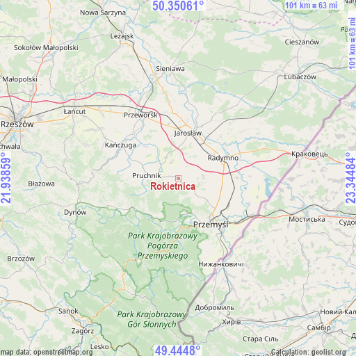
Rokietnica GPS coordinates[2]
49° 53' 59.388" North, 22° 38' 30.156" East
| Map corner | latitude | longitude |
|---|---|---|
| Upper-left | 50.35061°, | 21.93859° |
| Center: | 49.89983°, | 22.64171° |
| Lower-right: | 49.4448°, | 23.34484° |
| Map W x H: | 100.7×100.7 km | = 62.6×62.6mi |
| max Lat: | 54.83135° ⇑87.6% North |
| Rokietnica: | 49.89983° |
| min Lat: | ⇓12.4% South 49.21328° |
| min Long | Rokietnica | max Long |
| 14.20249° | 22.64171° | 24.03723° |
| W 93.2%⇐ | ⇒6.8% E |
Elevation
Elevation of Rokietnica is 239 m = 784 ft, and this is 47.6 m = 156 ft above average elevation for this country.
| Max E: |
974 m = 3196 ft | 27.2% |
| Rokietnica | 239 m 784 ft | |
| Avg. | 191.4 m = 628 ft | |
Min E: |
-3 m = -10 ft | 72.8% |
See also: Poland elevation on elevation.city.
Geographical zone
Rokietnica is located in North temperate zone (between Tropic of Cancer and the Arctic Circle). Distance of this North polar circle is 1852.8 km =1151.3 mi to North.| Distance of | km | miles | from Rokietnica |
|---|---|---|---|
| North Pole | 4458.7 | 2770.5 | to North |
| Arctic Circle | 1852.8 | 1151.3 | to North |
| Tropic Cancer | 2942.4 | 1828.3 | to South |
| Equator | 5548.3 | 3447.6 | to South |


Nearby cities:
15 places around Rokietnica: (largest is in red/bold)
• Chłopice
5.9 km =3.7 mi,  23°
23°
• Cieszacin Wielki
11 km =6.8 mi,  341°
341°
• Jankowice
7 km =4.3 mi,  3°
3°
• Jarosław
13.2 km =8.2 mi,  11°
11°
• Jodłówka
12.6 km =7.8 mi,  267°
267°
• Kramarzówka
11 km =6.8 mi,  246°
246°
• Krzywcza
13.2 km =8.2 mi,  211°
211°
• Orły
12 km =7.5 mi,  105°
105°
• Ostrów
12.9 km =8 mi,  53°
53°
• Pawłosiów
10.6 km =6.6 mi, 2°
• Pruchnik
9.1 km =5.7 mi, 274°
• Rożniatów
12.6 km =7.8 mi,  313°
313°
• Rożwienica
6.8 km =4.2 mi,  330°
330°
• Węgierka
6 km =3.7 mi,  257°
257°
• Zarzecze
12.2 km =7.6 mi,  322°
322°
Sources, notices
• [Note1] Compared only with cities in Poland existing in our database
• [Src1] Map data: © OpenStreetMap contributors (CC-BY-SA)
• [Src2] Other city data from geonames.org with taken over terms of usage.
• [Src3] Geographical zone / Annual Mean Temperature by Robert A. Rohde @ Wikipedia
