Małkowice geodata
Małkowice (Subcarpathian) is a populated place; located in Poland in Europe/Warsaw (GMT+2) time zone. With population of 810 people, there are 2835 cities with bigger population in this country. Compared to other cities in Poland, 89.5% of cities are located further ↑North; 94.7% of cities are located further ←West and 62.4% of cities have lower elevation than Małkowice. Note1


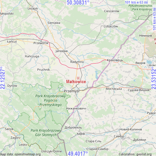
Małkowice GPS coordinates[2]
49° 51' 25.668" North, 22° 49' 42.204" East
| Map corner | latitude | longitude |
|---|---|---|
| Upper-left | 50.30831°, | 22.12527° |
| Center: | 49.85713°, | 22.82839° |
| Lower-right: | 49.4017°, | 23.53152° |
| Map W x H: | 100.8×100.8 km | = 62.6×62.6mi |
| max Lat: | 54.83135° ⇑89.5% North |
| Małkowice: | 49.85713° |
| min Lat: | ⇓10.5% South 49.21328° |
| min Long | Małkowice | max Long |
| 14.20249° | 22.82839° | 24.03723° |
| W 94.7%⇐ | ⇒5.3% E |
Elevation
Elevation of Małkowice is 207 m = 679 ft, and this is 15.6 m = 51 ft above average elevation for this country.
| Max E: |
974 m = 3196 ft | 37.6% |
| Małkowice | 207 m 679 ft | |
| Avg. | 191.4 m = 628 ft | |
Min E: |
-3 m = -10 ft | 62.4% |
See also: Poland elevation on elevation.city.
Geographical zone
Małkowice is located in North temperate zone (between Tropic of Cancer and the Arctic Circle). Distance of this North polar circle is 1857.6 km =1154.3 mi to North.| Distance of | km | miles | from Małkowice |
|---|---|---|---|
| North Pole | 4463.5 | 2773.5 | to North |
| Arctic Circle | 1857.6 | 1154.3 | to North |
| Tropic Cancer | 2937.7 | 1825.4 | to South |
| Equator | 5543.6 | 3444.6 | to South |


Nearby cities:
15 places around Małkowice: (largest is in red/bold)
• Chłopice
15 km =9.3 mi,  312°
312°
• Fredropol
18.9 km =11.7 mi,  198°
198°
• Jankowice
17.5 km =10.9 mi, 312°
• Krasiczyn
15.5 km =9.6 mi,  234°
234°
• Laszki
18.8 km =11.7 mi,  15°
15°
• Medyka
8.9 km =5.5 mi,  130°
130°
• Nakło
9.8 km =6.1 mi,  76°
76°
• Orły
2.4 km =1.5 mi, 310°
• Ostrów
12.7 km =7.9 mi,  346°
346°
• Przemyśl
9.1 km =5.7 mi,  208°
208°
• Radymno
10 km =6.2 mi,  358°
358°
• Rokietnica
14.2 km =8.8 mi,  289°
289°
• Sośnica
5.9 km =3.7 mi,  34°
34°
• Stubno
10.2 km =6.3 mi,  63°
63°
• Żurawica
4.7 km =2.9 mi,  216°
216°
Sources, notices
• [Note1] Compared only with cities in Poland existing in our database
• [Src1] Map data: © OpenStreetMap contributors (CC-BY-SA)
• [Src2] Other city data from geonames.org with taken over terms of usage.
• [Src3] Geographical zone / Annual Mean Temperature by Robert A. Rohde @ Wikipedia
