Nadarzyn geodata
Nadarzyn (Mazovia) is a seat of a third-order administrative division; located in Poland in Europe/Warsaw (GMT+2) time zone. With population of 9,881 people, there are 451 cities with bigger population in this country. Compared to other cities in Poland, 67.7% of cities are located further ↓South; 69.2% of cities are located further ←West and 75% of cities have higher elevation than Nadarzyn. Note1


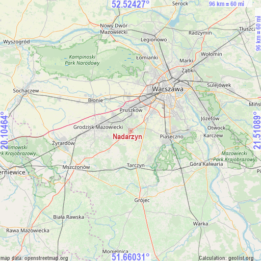
Nadarzyn GPS coordinates[2]
52° 5' 39.768" North, 20° 48' 27.936" East
| Map corner | latitude | longitude |
|---|---|---|
| Upper-left | 52.52427°, | 20.10464° |
| Center: | 52.09438°, | 20.80776° |
| Lower-right: | 51.66031°, | 21.51089° |
| Map W x H: | 96.1×96.1 km | = 59.7×59.7mi |
| max Lat: | 54.83135° ⇑32.3% North |
| Nadarzyn: | 52.09438° |
| min Lat: | ⇓67.7% South 49.21328° |
| min Long | Nadarzyn | max Long |
| 14.20249° | 20.80776° | 24.03723° |
| W 69.2%⇐ | ⇒30.8% E |
Elevation
Elevation of Nadarzyn is 111 m = 364 ft, and this is 80.4 m = 264 ft below average elevation for this country.
| Max E: |
974 m = 3196 ft | 75% |
| Avg. | 191.4 m = 628 ft | |
| Nadarzyn | 111 m = 364 ft | |
Min E: |
-3 m = -10 ft | 25% |
See also: Poland elevation on elevation.city.
Geographical zone
Nadarzyn is located in North temperate zone (between Tropic of Cancer and the Arctic Circle). Distance of this North polar circle is 1608.8 km =999.7 mi to North.| Distance of | km | miles | from Nadarzyn |
|---|---|---|---|
| North Pole | 4214.7 | 2618.9 | to North |
| Arctic Circle | 1608.8 | 999.7 | to North |
| Tropic Cancer | 3186.4 | 1979.9 | to South |
| Equator | 5792.4 | 3599.2 | to South |


Nearby cities:
15 places around Nadarzyn: (largest is in red/bold)
• Brwinów
8.2 km =5.1 mi,  310°
310°
• Granica
4.4 km =2.7 mi,  355°
355°
• Kanie
5.6 km =3.5 mi,  331°
331°
• Komorów
5.7 km =3.5 mi,  5°
5°
• Książenice
7.8 km =4.8 mi,  256°
256°
• Lesznowola
8.7 km =5.4 mi,  92°
92°
• Michałowice
10.2 km =6.3 mi,  29°
29°
• Milanówek
9.7 km =6 mi,  286°
286°
• Nowe Grocholice
10.1 km =6.3 mi,  44°
44°
• Otrębusy
5 km =3.1 mi,  319°
319°
• Owczarnia
7.3 km =4.5 mi,  284°
284°
• Piastów
10.2 km =6.3 mi, 12°
• Podkowa Leśna
6.4 km =4 mi,  299°
299°
• Pruszków
8.5 km =5.3 mi,  2°
2°
• Reguły
9.8 km =6.1 mi,  23°
23°
Sources, notices
• [Note1] Compared only with cities in Poland existing in our database
• [Src1] Map data: © OpenStreetMap contributors (CC-BY-SA)
• [Src2] Other city data from geonames.org with taken over terms of usage.
• [Src3] Geographical zone / Annual Mean Temperature by Robert A. Rohde @ Wikipedia
