Milanówek geodata
Milanówek (Mazovia) is a seat of a third-order administrative division; located in Poland in Europe/Warsaw (GMT+2) time zone. With population of 15,784 people, there are 316 cities with bigger population in this country. Compared to other cities in Poland, 68.3% of cities are located further ↓South; 67.1% of cities are located further ←West and 78.8% of cities have higher elevation than Milanówek. Note1


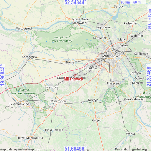
Milanówek GPS coordinates[2]
52° 7' 7.644" North, 20° 40' 17.58" East
| Map corner | latitude | longitude |
|---|---|---|
| Upper-left | 52.54844°, | 19.96843° |
| Center: | 52.11879°, | 20.67155° |
| Lower-right: | 51.68496°, | 21.37468° |
| Map W x H: | 96×96 km | = 59.7×59.7mi |
| max Lat: | 54.83135° ⇑31.7% North |
| Milanówek: | 52.11879° |
| min Lat: | ⇓68.3% South 49.21328° |
| min Long | Milanówek | max Long |
| 14.20249° | 20.67155° | 24.03723° |
| W 67.1%⇐ | ⇒32.9% E |
Elevation
Elevation of Milanówek is 102 m = 335 ft, and this is 89.4 m = 293 ft below average elevation for this country.
| Max E: |
974 m = 3196 ft | 78.8% |
| Avg. | 191.4 m = 628 ft | |
| Milanówek | 102 m = 335 ft | |
Min E: |
-3 m = -10 ft | 21.2% |
See also: Poland elevation on elevation.city.
Geographical zone
Milanówek is located in North temperate zone (between Tropic of Cancer and the Arctic Circle). Distance of this North polar circle is 1606.1 km =998 mi to North.| Distance of | km | miles | from Milanówek |
|---|---|---|---|
| North Pole | 4212 | 2617.2 | to North |
| Arctic Circle | 1606.1 | 998 | to North |
| Tropic Cancer | 3189.1 | 1981.6 | to South |
| Equator | 5795.1 | 3600.9 | to South |


Nearby cities:
15 places around Milanówek: (largest is in red/bold)
• Bieniewice
10.3 km =6.4 mi,  313°
313°
• Brwinów
4.1 km =2.5 mi,  49°
49°
• Błonie
9.6 km =6 mi,  337°
337°
• Granica
9.1 km =5.7 mi,  79°
79°
• Grodzisk Mazowiecki
3.1 km =1.9 mi,  237°
237°
• Jaktorów
9.7 km =6 mi, 242°
• Józefów
8.6 km =5.3 mi,  11°
11°
• Kanie
7 km =4.3 mi,  71°
71°
• Komorów
10.3 km =6.4 mi, 73°
• Książenice
4.9 km =3 mi,  159°
159°
• Nadarzyn
9.7 km =6 mi,  106°
106°
• Otrębusy
6.2 km =3.9 mi, 80°
• Owczarnia
2.4 km =1.5 mi, 110°
• Podkowa Leśna
3.8 km =2.4 mi, 83°
• Żabia Wola
9.8 km =6.1 mi,  172°
172°
Sources, notices
• [Note1] Compared only with cities in Poland existing in our database
• [Src1] Map data: © OpenStreetMap contributors (CC-BY-SA)
• [Src2] Other city data from geonames.org with taken over terms of usage.
• [Src3] Geographical zone / Annual Mean Temperature by Robert A. Rohde @ Wikipedia
