Podkowa Leśna geodata
Podkowa Leśna (Mazovia) is a seat of a third-order administrative division; located in Poland in Europe/Warsaw (GMT+2) time zone. With population of 3,844 people, there are 848 cities with bigger population in this country. Compared to other cities in Poland, 68.3% of cities are located further ↓South; 68.2% of cities are located further ←West and 77.6% of cities have higher elevation than Podkowa Leśna. Note1


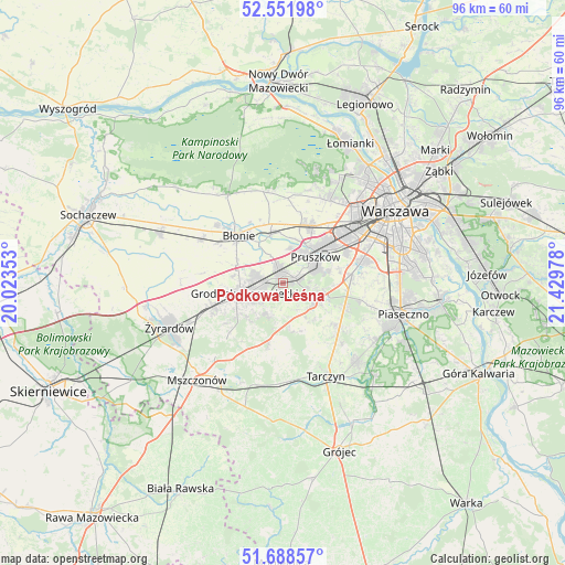
Podkowa Leśna GPS coordinates[2]
52° 7' 20.532" North, 20° 43' 35.94" East
| Map corner | latitude | longitude |
|---|---|---|
| Upper-left | 52.55198°, | 20.02353° |
| Center: | 52.12237°, | 20.72665° |
| Lower-right: | 51.68857°, | 21.42978° |
| Map W x H: | 96×96 km | = 59.7×59.7mi |
| max Lat: | 54.83135° ⇑31.7% North |
| Podkowa Leśna: | 52.12237° |
| min Lat: | ⇓68.3% South 49.21328° |
| min Long | Podkowa Leśna | max Long |
| 14.20249° | 20.72665° | 24.03723° |
| W 68.2%⇐ | ⇒31.8% E |
Elevation
Elevation of Podkowa Leśna is 104 m = 341 ft, and this is 87.4 m = 287 ft below average elevation for this country.
| Max E: |
974 m = 3196 ft | 77.6% |
| Avg. | 191.4 m = 628 ft | |
| Podkowa Leśna | 104 m = 341 ft | |
Min E: |
-3 m = -10 ft | 22.4% |
See also: Poland elevation on elevation.city.
Geographical zone
Podkowa Leśna is located in North temperate zone (between Tropic of Cancer and the Arctic Circle). Distance of this North polar circle is 1605.7 km =997.7 mi to North.| Distance of | km | miles | from Podkowa Leśna |
|---|---|---|---|
| North Pole | 4211.6 | 2617 | to North |
| Arctic Circle | 1605.7 | 997.7 | to North |
| Tropic Cancer | 3189.5 | 1981.9 | to South |
| Equator | 5795.5 | 3601.2 | to South |


Nearby cities:
15 places around Podkowa Leśna: (largest is in red/bold)
• Brwinów
2.4 km =1.5 mi,  343°
343°
• Duchnice
10.1 km =6.3 mi,  29°
29°
• Granica
5.4 km =3.4 mi,  76°
76°
• Grodzisk Mazowiecki
6.7 km =4.2 mi,  252°
252°
• Józefów
8.3 km =5.2 mi,  345°
345°
• Kanie
3.4 km =2.1 mi,  58°
58°
• Komorów
6.6 km =4.1 mi,  66°
66°
• Książenice
5.4 km =3.4 mi,  202°
202°
• Milanówek
3.8 km =2.4 mi,  263°
263°
• Nadarzyn
6.4 km =4 mi,  119°
119°
• Otrębusy
2.4 km =1.5 mi, 73°
• Owczarnia
2 km =1.2 mi,  230°
230°
• Ołtarzew
10.2 km =6.3 mi,  12°
12°
• Piastów
10.3 km =6.4 mi,  48°
48°
• Pruszków
7.9 km =4.9 mi, 47°
Sources, notices
• [Note1] Compared only with cities in Poland existing in our database
• [Src1] Map data: © OpenStreetMap contributors (CC-BY-SA)
• [Src2] Other city data from geonames.org with taken over terms of usage.
• [Src3] Geographical zone / Annual Mean Temperature by Robert A. Rohde @ Wikipedia
