Pruszków geodata
Pruszków (Mazovia) is a seat of a second-order administrative division; located in Poland in Europe/Warsaw (GMT+2) time zone. With population of 55,371 people, there are 94 cities with bigger population in this country. Compared to other cities in Poland, 69.4% of cities are located further ↓South; 69.4% of cities are located further ←West and 83.7% of cities have higher elevation than Pruszków. Note1


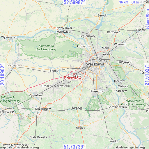
Pruszków GPS coordinates[2]
52° 10' 14.592" North, 20° 48' 43.704" East
| Map corner | latitude | longitude |
|---|---|---|
| Upper-left | 52.59987°, | 20.10902° |
| Center: | 52.17072°, | 20.81214° |
| Lower-right: | 51.73739°, | 21.51527° |
| Map W x H: | 95.9×95.9 km | = 59.6×59.6mi |
| max Lat: | 54.83135° ⇑30.6% North |
| Pruszków: | 52.17072° |
| min Lat: | ⇓69.4% South 49.21328° |
| min Long | Pruszków | max Long |
| 14.20249° | 20.81214° | 24.03723° |
| W 69.4%⇐ | ⇒30.6% E |
Elevation
Elevation of Pruszków is 92 m = 302 ft, and this is 99.4 m = 326 ft below average elevation for this country.
| Max E: |
974 m = 3196 ft | 83.7% |
| Avg. | 191.4 m = 628 ft | |
| Pruszków | 92 m = 302 ft | |
Min E: |
-3 m = -10 ft | 16.3% |
See also: Pruszków elevation on elevation.city.
Geographical zone
Pruszków is located in North temperate zone (between Tropic of Cancer and the Arctic Circle). Distance of this North polar circle is 1600.3 km =994.4 mi to North.| Distance of | km | miles | from Pruszków |
|---|---|---|---|
| North Pole | 4206.2 | 2613.6 | to North |
| Arctic Circle | 1600.3 | 994.4 | to North |
| Tropic Cancer | 3194.9 | 1985.2 | to South |
| Equator | 5800.8 | 3604.4 | to South |


Nearby cities:
15 places around Pruszków: (largest is in red/bold)
• Brwinów
7.2 km =4.5 mi,  244°
244°
• Duchnice
3.5 km =2.2 mi,  345°
345°
• Granica
4.2 km =2.6 mi,  188°
188°
• Kanie
4.6 km =2.9 mi,  219°
219°
• Komorów
2.8 km =1.7 mi,  175°
175°
• Michałowice
4.7 km =2.9 mi,  85°
85°
• Nowe Grocholice
6.9 km =4.3 mi,  100°
100°
• Otrębusy
5.9 km =3.7 mi, 216°
• Ołtarzew
5.8 km =3.6 mi,  321°
321°
• Ożarów Mazowiecki
4.5 km =2.8 mi, 346°
• Piastów
2.4 km =1.5 mi,  50°
50°
• Podkowa Leśna
7.9 km =4.9 mi,  227°
227°
• Raszyn
7.7 km =4.8 mi, 102°
• Reguły
3.6 km =2.2 mi,  81°
81°
• Ursus
5.6 km =3.5 mi,  61°
61°
Sources, notices
• [Note1] Compared only with cities in Poland existing in our database
• [Src1] Map data: © OpenStreetMap contributors (CC-BY-SA)
• [Src2] Other city data from geonames.org with taken over terms of usage.
• [Src3] Geographical zone / Annual Mean Temperature by Robert A. Rohde @ Wikipedia
