Moszczenica geodata
Moszczenica (Lesser Poland) is a populated place; located in Poland in Europe/Warsaw (GMT+2) time zone. With population of 3,302 people, there are 965 cities with bigger population in this country. Compared to other cities in Poland, 93.4% of cities are located further ↑North; 74.4% of cities are located further ←West and 86.6% of cities have lower elevation than Moszczenica. Note1


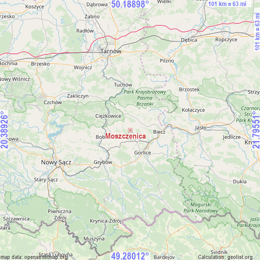
Moszczenica GPS coordinates[2]
49° 44' 12.048" North, 21° 5' 32.568" East
| Map corner | latitude | longitude |
|---|---|---|
| Upper-left | 50.18898°, | 20.38926° |
| Center: | 49.73668°, | 21.09238° |
| Lower-right: | 49.28012°, | 21.79551° |
| Map W x H: | 101.1×101.1 km | = 62.8×62.8mi |
| max Lat: | 54.83135° ⇑93.4% North |
| Moszczenica: | 49.73668° |
| min Lat: | ⇓6.6% South 49.21328° |
| min Long | Moszczenica | max Long |
| 14.20249° | 21.09238° | 24.03723° |
| W 74.4%⇐ | ⇒25.6% E |
Elevation
Elevation of Moszczenica is 299 m = 981 ft, and this is 107.6 m = 353 ft above average elevation for this country.
| Max E: |
974 m = 3196 ft | 13.4% |
| Moszczenica | 299 m 981 ft | |
| Avg. | 191.4 m = 628 ft | |
Min E: |
-3 m = -10 ft | 86.6% |
See also: Poland elevation on elevation.city.
Geographical zone
Moszczenica is located in North temperate zone (between Tropic of Cancer and the Arctic Circle). Distance of this North polar circle is 1871 km =1162.6 mi to North.| Distance of | km | miles | from Moszczenica |
|---|---|---|---|
| North Pole | 4476.9 | 2781.8 | to North |
| Arctic Circle | 1871 | 1162.6 | to North |
| Tropic Cancer | 2924.3 | 1817.1 | to South |
| Equator | 5530.2 | 3436.3 | to South |


Nearby cities:
15 places around Moszczenica: (largest is in red/bold)
• Biecz
12.3 km =7.6 mi,  90°
90°
• Binarowa
10 km =6.2 mi,  77°
77°
• Bobowa
10.9 km =6.8 mi,  253°
253°
• Bystra
8.3 km =5.2 mi,  183°
183°
• Ciężkowice
10.1 km =6.3 mi,  302°
302°
• Gorlice
10.3 km =6.4 mi,  151°
151°
• Kobylanka
12 km =7.5 mi,  128°
128°
• Korczyna
11.7 km =7.3 mi,  103°
103°
• Kwiatonowice
5.3 km =3.3 mi,  109°
109°
• Ołpiny
11.2 km =7 mi,  45°
45°
• Racławice
7.1 km =4.4 mi, 78°
• Rzepiennik Marciszewski
12.2 km =7.6 mi,  328°
328°
• Rzepiennik Strzyżewski
8.6 km =5.3 mi, 332°
• Łużna
4.2 km =2.6 mi,  231°
231°
• Żurowa
11.4 km =7.1 mi,  28°
28°
Sources, notices
• [Note1] Compared only with cities in Poland existing in our database
• [Src1] Map data: © OpenStreetMap contributors (CC-BY-SA)
• [Src2] Other city data from geonames.org with taken over terms of usage.
• [Src3] Geographical zone / Annual Mean Temperature by Robert A. Rohde @ Wikipedia
