Żurowa geodata
Żurowa (Lesser Poland) is a populated place; located in Poland in Europe/Warsaw (GMT+2) time zone. With population of 2,321 people, there are 1317 cities with bigger population in this country. Compared to other cities in Poland, 90.7% of cities are located further ↑North; 75.4% of cities are located further ←West and 86.6% of cities have lower elevation than Żurowa. Note1


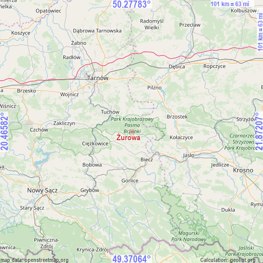
Żurowa GPS coordinates[2]
49° 49' 34.896" North, 21° 10' 8.184" East
| Map corner | latitude | longitude |
|---|---|---|
| Upper-left | 50.27783°, | 20.46582° |
| Center: | 49.82636°, | 21.16894° |
| Lower-right: | 49.37064°, | 21.87207° |
| Map W x H: | 100.9×100.9 km | = 62.7×62.7mi |
| max Lat: | 54.83135° ⇑90.7% North |
| Żurowa: | 49.82636° |
| min Lat: | ⇓9.3% South 49.21328° |
| min Long | Żurowa | max Long |
| 14.20249° | 21.16894° | 24.03723° |
| W 75.4%⇐ | ⇒24.6% E |
Elevation
Elevation of Żurowa is 299 m = 981 ft, and this is 107.6 m = 353 ft above average elevation for this country.
| Max E: |
974 m = 3196 ft | 13.4% |
| Żurowa | 299 m 981 ft | |
| Avg. | 191.4 m = 628 ft | |
Min E: |
-3 m = -10 ft | 86.6% |
See also: Poland elevation on elevation.city.
Geographical zone
Żurowa is located in North temperate zone (between Tropic of Cancer and the Arctic Circle). Distance of this North polar circle is 1861 km =1156.4 mi to North.| Distance of | km | miles | from Żurowa |
|---|---|---|---|
| North Pole | 4466.9 | 2775.6 | to North |
| Arctic Circle | 1861 | 1156.4 | to North |
| Tropic Cancer | 2934.3 | 1823.3 | to South |
| Equator | 5540.2 | 3442.5 | to South |


Nearby cities:
15 places around Żurowa: (largest is in red/bold)
• Biecz
12.1 km =7.5 mi,  146°
146°
• Binarowa
8.9 km =5.5 mi, 151°
• Jabłonica
12 km =7.5 mi,  107°
107°
• Jodłowa
9.4 km =5.8 mi,  57°
57°
• Karwodrza
13.1 km =8.1 mi,  328°
328°
• Kwiatonowice
11.8 km =7.3 mi,  182°
182°
• Lubaszowa
10.1 km =6.3 mi,  291°
291°
• Moszczenica
11.4 km =7.1 mi,  208°
208°
• Ołpiny
3.4 km =2.1 mi,  130°
130°
• Racławice
8.7 km =5.4 mi,  170°
170°
• Ryglice
6.3 km =3.9 mi,  338°
338°
• Rzepiennik Marciszewski
11.8 km =7.3 mi,  272°
272°
• Rzepiennik Strzyżewski
9.8 km =6.1 mi,  256°
256°
• Szerzyny
5.9 km =3.7 mi, 108°
• Tuchów
11.2 km =7 mi,  312°
312°
Sources, notices
• [Note1] Compared only with cities in Poland existing in our database
• [Src1] Map data: © OpenStreetMap contributors (CC-BY-SA)
• [Src2] Other city data from geonames.org with taken over terms of usage.
• [Src3] Geographical zone / Annual Mean Temperature by Robert A. Rohde @ Wikipedia
